Map of the Tang Dynasty
754–906 · About this map
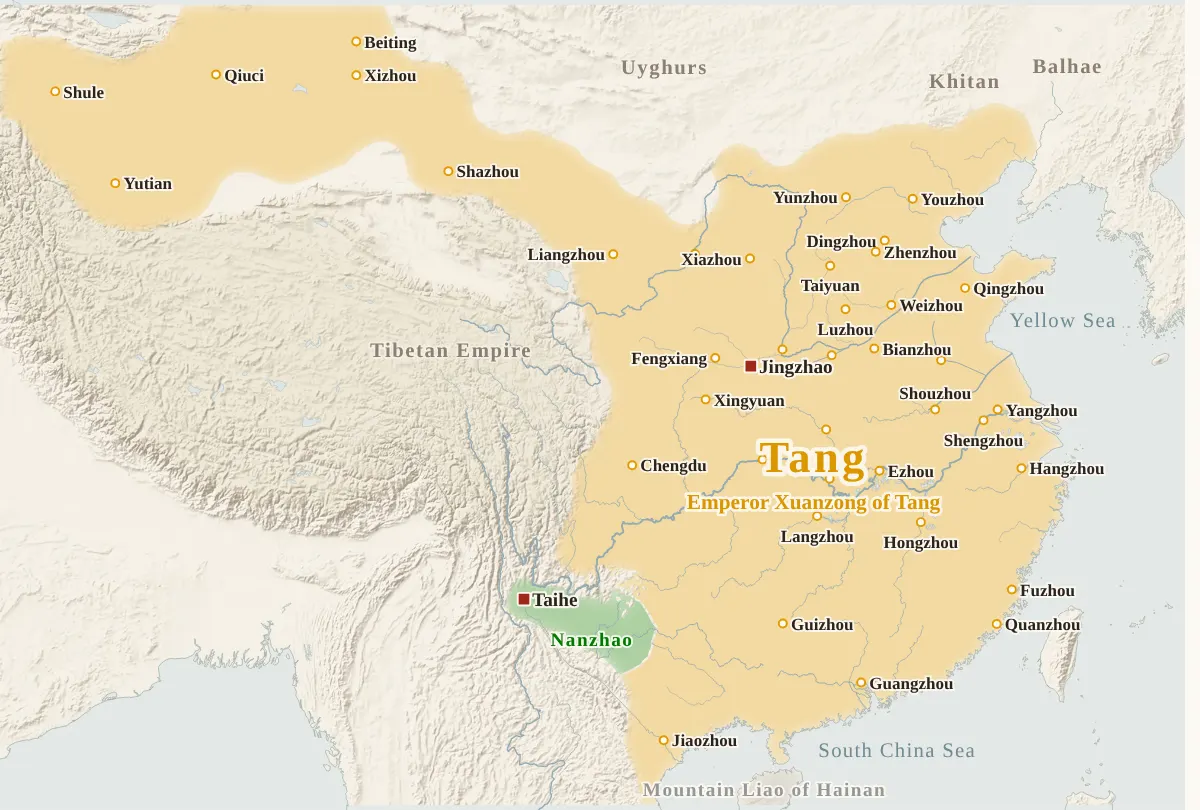
Loading the map…
754
This year
Tap a city on the map, or a city name below, to see who held it year by year. Pinch or tap + to zoom in and see the smaller cities.
How the period unfolded
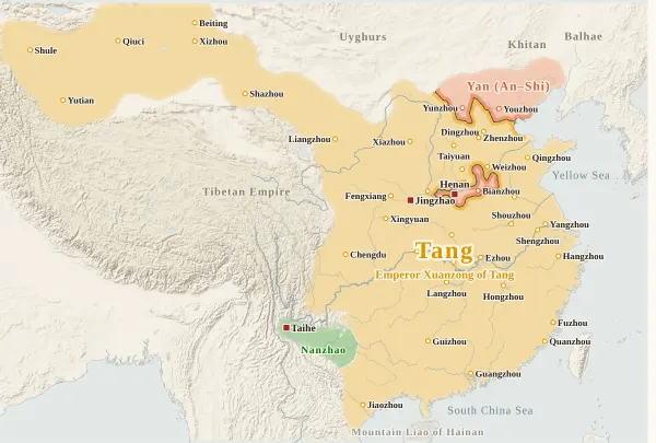
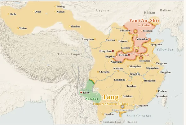
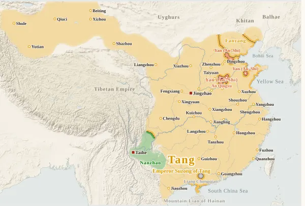
An Lushan Rebellion754–763
Military governors764–874
Huang Chao875–894
Fall of Tang895–906
Emperors of the Tang period
Each dynasty's page lists its emperors with their reigns and causes of death.
About this map
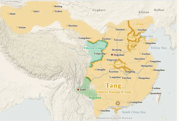
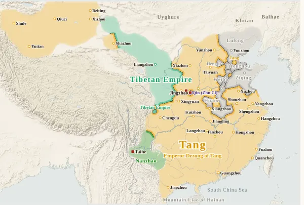
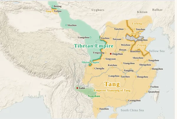
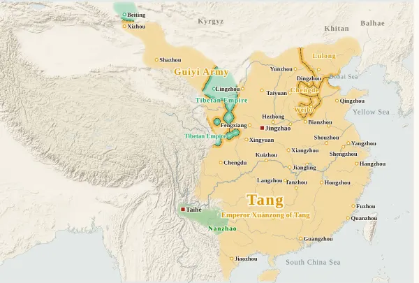
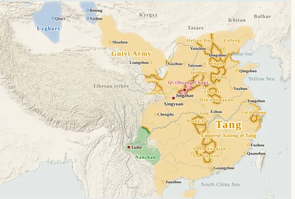
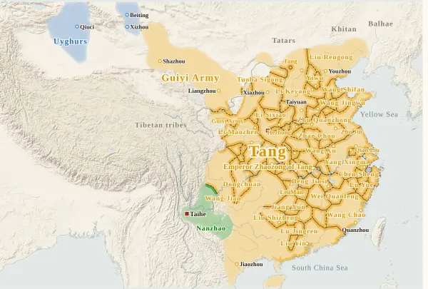
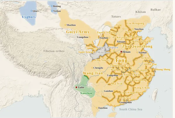
This map covers the years from 754 (the 13th year of Tianbao), the year before An Lushan rose in revolt, to 906 (the 3rd year of Tianyou), the year before the Tang fell. For every year it records who held each prefecture at the end of the year, taken from the histories, and draws each power's territory from that. Move the year to watch the borders shift; click a prefecture to see who held it, year by year.
The coloured powers are the Tang; the states that took the Tang capital and claimed the title of emperor — Yan (An Lushan and Shi Siming), Qin (Zhu Ci) and Qi (Huang Chao); Chu (Li Xilie), which claimed it at Bianzhou; and the Tibetan Empire, Nanzhao and the Uyghurs. The Khitan, the Xi, Balhae, the Tanguts, the Kyrgyz and others appear only as names at the edges of the map.
The red square marks the city where an emperor or king was at the end of the year. In years when the Tang emperor spent the end of the year away from the capital, Chang'an, it is placed where he was: Ningzhou (Pengyuan) in 756, Fengtian in 783 and Xingyuan in 880, for example.
The military provinces (fanzhen, governed by military governors) are shown in three ways. Provinces that obeyed the court keep the Tang colour. Provinces whose governors the court could not appoint, and which passed from father to son or to a subordinate — the three Hebei provinces (Chengde, Weibo and Lulong), Ziqing, Huaixi and others — are drawn as separate areas in the Tang colour with the province's name (a prefecture's history marks them “nominal”). In years when the court ordered a campaign against a province, or its governor called himself king or emperor, it is grey, outside the Tang. The warlords who fought over the prefectures in the late Tang (Zhu Quanzhong, Li Keyong, Yang Xingmi, Wang Jian and others) are also drawn in the Tang colour with their names for as long as they held Tang offices.
The “greatest extent of the Tang” often seen in textbooks and online is a map of the 660s, under Gaozong, that counts nominal prefectures (jimi prefectures) from Central Asia to the Mongolian steppe. This map starts in 754, the year before the An Lushan Rebellion, and does not draw nominal prefectures, so its western and northern edges look different. Here the western edge of the Tang in 754 is the Four Garrisons of Anxi (Qiuci, Yutian, Shule and Yanqi) and Beiting.
Click the gear at the bottom right of the map and turn on “Show modern cities” to see provincial capitals and other cities of today. Type a modern name such as “Nanjing” into “Find by modern name” under the same gear to open the prefecture at that place.
Years follow the year divisions of the Zizhi Tongjian. Events of the twelfth month count in that year, though by the modern calendar they may fall in January or February of the next (the twelfth month of the first year of Guangming, when Huang Chao proclaimed himself emperor in Chang'an, was January 881 by the modern calendar).
How this map was made
For 237 major prefectures, we took from the histories who held the prefecture's city at the end of each year, and attached the source passage to every change of hands. The main source is the Zizhi Tongjian, checked against the Old and New Books of Tang (the basic annals, the treatises on geography and the biographies), with the Old and New Histories of the Five Dynasties and the Shiguo Chunqiu for the late Tang: 1,723 passages in all, each machine-checked to appear word for word in the text, and for the Zizhi Tongjian to appear under the heading of that year. Sieges and occupations given up within the year do not change a prefecture's holder (as when the Arabs and Persians burned Guangzhou and left in 758, or when Huang Chao took Guangzhou and went north again in 879).
The borders are inferred by machine from who held the prefectures. The land is divided into 4 km squares, and each square is given to the power whose prefecture can be reached from it with the least effort, allowing for steep mountains and the difficulty of crossing great rivers. Land far from every prefecture (steppe, desert, plateau, the uplands of non-Han peoples) is left uncoloured and fades out. Liangzhou, Ganzhou and Suzhou in Hexi are coloured as widely as other prefectures; Guazhou, Shazhou, Yizhou, Xizhou and Beiting to the west are oasis cities in the desert and are coloured a little more narrowly. The Four Garrisons of Anxi (Qiuci, Yutian, Shule and Yanqi) lie hundreds of kilometres apart, so a wider area is coloured around each, so that the rim of the Tarim Basin reads as one stretch of Tang land.
Where the prefectures of one power lie apart and its colour breaks off, they are joined by a band along a route that does not cross another power's land (up to about 400 km on level ground). A prefecture surrounded by another power's land (an exclave) is drawn as a circle about 36 km in radius.
Borders at the time were zones rather than lines, and the lines on this map show only roughly where those zones lay.
Limits
- Neither the Zizhi Tongjian nor the two Books of Tang record directly when the Hexi prefectures fell to the Tibetan Empire. Ganzhou and Suzhou are placed in 766, when the Hexi governor moved to Shazhou; Guazhou and Yizhou in 781, the latest year by which they are known to have fallen; and Shazhou, which fell some time between 777 and 792, in 786. The histories used also give no year for Zhang Yichao's recovery of Shazhou in 848, so the prefectures of the Guiyi Army are counted from 851, when he submitted to the Tang.
- After Beiting fell to the Tibetan Empire in 790, the Four Garrisons of Anxi were cut off from the Tang, and the Zizhi Tongjian says that year that no one knew whether they still stood. The histories used give no year for who held them afterwards, so from 790 the Four Garrisons are left uncoloured, as cities with no clear holder (Qiuci is counted as Uyghur from 856, when the Uyghur qaghan is recorded as being at Anxi). The treatise on geography of the New Book of Tang puts the fall of Anxi in 787, but the Zizhi Tongjian still names Anxi in 790, and this map follows it.
- The Tibetan state “declined and came to an end” (Zizhi Tongjian) when Lun Kongre was killed in 866, and did not survive as a state afterwards, so from 866 the name on the plateau is “Tibetan tribes”. Taozhou, Huizhou, Songzhou and Jiezhou (Jiezhou until 889), for which no Tang recovery is recorded, are left uncoloured from 866 as cities with no clear holder. Settlements of people who had been subjects of the Tibetans are known to have been scattered across Hexi and Longyou, but the histories do not say who held which prefecture.
- Where the histories disagree on a year, the map follows the Zizhi Tongjian (for example, the recovery of Liangzhou in 863, the fall of Beiting in 790, and Dong Chang's entry into Hangzhou in 881). Movements of late-Tang warlords dated only in the New Book of Tang or the Shiguo Chunqiu (Zhou Yue, Lei Man and Chen Yanqian in Hunan in 879, Zhangzhou in Fujian passing to Wang Chao in 893, and others) may be off by a year or two.
- In the late Tang (the 880s to 906), many prefectures have no record naming who held them; these keep their previous holder (Ruzhou, Huaizhou, Yuanzhou, Xiazhou and others). The eleven prefectures of the Guiyi Army are also kept as Guiyi Army until 906: its submission was only nominal and some prefectures later passed to other powers, but it is not known which ones or when.
- The colours of the military provinces were decided year by year from the records of whether the court could appoint the governor and whether a campaign was ordered against him. For Cui Gan and Liu Pi (both Xichuan), “nominal” is applied only to Chengdu, not to the prefectures under it.
- Prefecture dots are placed at the present-day city or county, not at the exact ancient site. Yuanzhou is placed at Pinggao (today's Guyuan) and Weizhou at Xiangwu (today's Longxi County); the later temporary seats of the two prefectures (Zhenyuan and Pingliang) are not drawn. The Nanzhao capital moved from Taihe to Yangjumie (the old town of Dali today) in 779, so the dot is at Yangjumie. Shunzhou (seated inside the city of Youzhou) and the Andong Protectorate (whose seat in 754 cannot be placed today) have no dot.
- Coastlines and most rivers are modern.
- The Tang uses the site's dynasty colour; the others have colours of their own on this map. The military provinces and warlords drawn in the Tang colour with their names are separate areas of the same colour (tell them apart by name).
Sources and licences
- Texts of the histories: the Daizhige (殆知閣) digital texts (quotations kept in simplified characters): the Zizhi Tongjian (with Hu Sanxing's commentary), the Old Book of Tang, the New Book of Tang, the Old History of the Five Dynasties, the New History of the Five Dynasties and the Shiguo Chunqiu
- Coastlines, rivers, lakes, modern cities and provincial borders: Natural Earth (public domain)
- Relief shading: NOAA ETOPO1 (public domain)
Japanese version
The Japanese version of this map also shows what happened each year, notes on every uncertain point, and the source passages (in Classical Chinese) for each change of hands: 唐の勢力図.