Map of the Warring States
260–221 BC · Before the first emperor · About this map
Loading the map…
260 BC
This year
Tap a city on the map, or a city name below, to see who held it year by year.
Key years
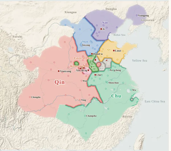 260 BCBattle of Changping
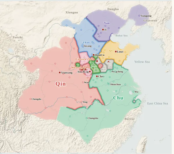 257 BCLord Xinling lifts the siege of Handan
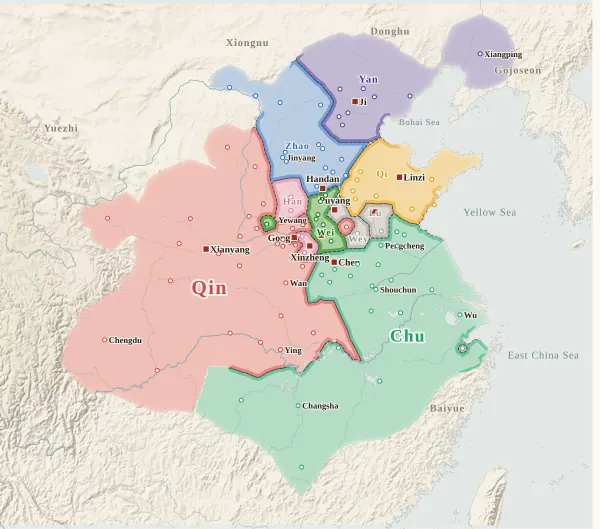 256 BCWestern Zhou submits to Qin
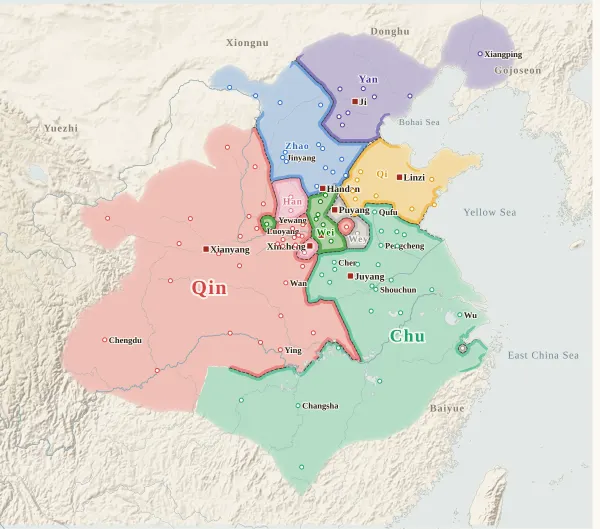 249 BCEastern Zhou falls
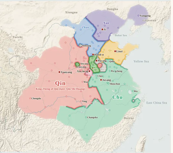 247 BCKing Zheng of Qin takes the throne
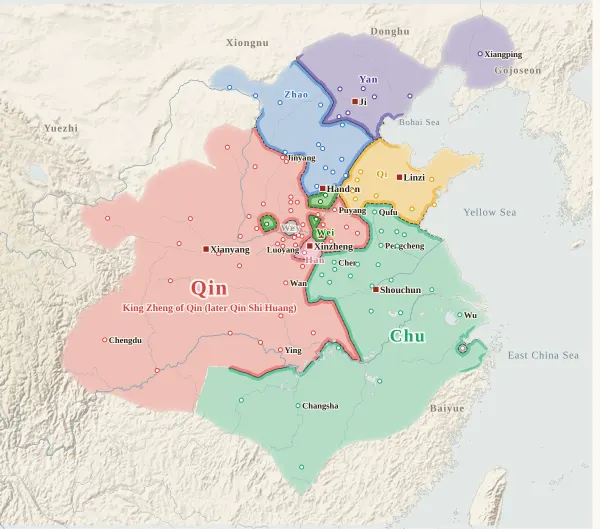 241 BCFive states join forces against Qin
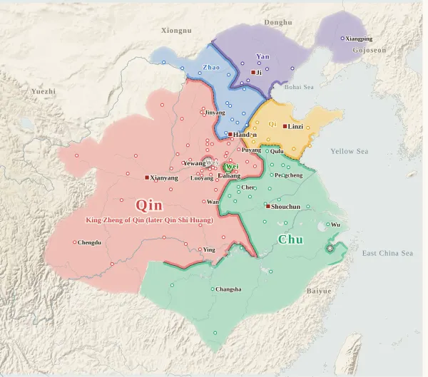 230 BCHan falls
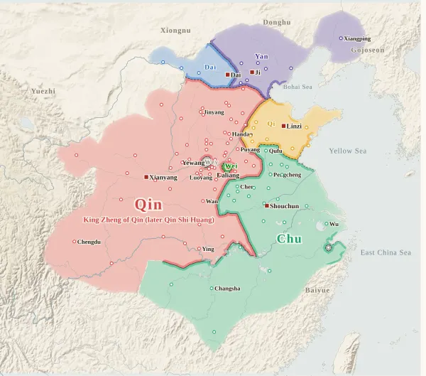 228 BCHandan falls
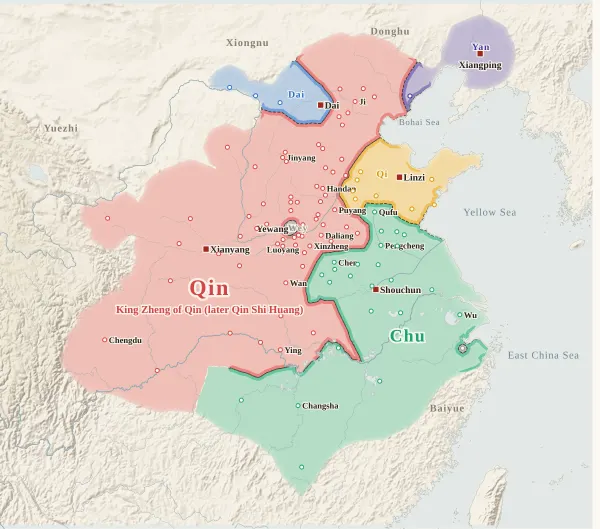 225 BCWei falls
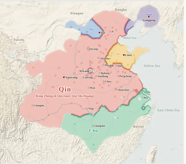 223 BCChu falls
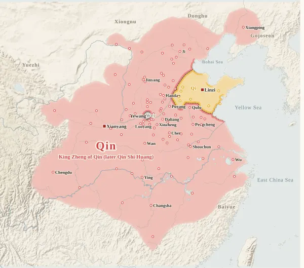 222 BCYan and Dai fall
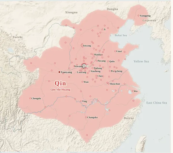 221 BCQi surrenders and Qin unifies China
The emperors who came next: Qin and Western Han
There was no emperor yet in this map's period. In 221 BC King Zheng of Qin took the title of emperor, becoming Qin Shi Huang. Click a dynasty to see its emperors with their portraits.
About this map
This map covers the end of the Warring States period, when the seven great states fought until Qin destroyed the other six and unified China. From 260 BC, when Qin crushed the great army of Zhao at Changping, to 221 BC, when Qin received the surrender of Qi, it records who held each major city at the end of every year, taken from the histories, and draws each state's territory from that. Move the year to watch the borders shift; click a city to see who held it, year by year, with the source passages.
This is the age before there were emperors. The first ruler in China to call himself emperor was King Zheng of Qin (Qin Shi Huang), who unified China in 221 BC; the rulers of the Warring States before him called themselves kings. So, unlike the other maps, this one does not show the kings' names under the state names. Only King Zheng of Qin is shown: from his accession in 247 BC as “King Zheng of Qin (later Qin Shi Huang)”, and in 221 BC as Qin Shi Huang. Click the name to go to his page.
The map shows the Seven Warring States (Qin, Han, Wei, Zhao, Yan, Qi and Chu); the small states that still held cities, Eastern Zhou, Western Zhou, Lu and Wey (衛, spelled so to tell it apart from Wei 魏); and Dai, where Prince Jia called himself king after the fall of Zhao (228 BC). The Xiongnu, Donghu, Yuezhi, Gojoseon and Baiyue appear only as names at the edges of the map.
Western Zhou and Eastern Zhou here are not the periods of the same names (the Zhou with its capital at Hao, and the Zhou after the move to Luoyang). They are two small states formed in the middle of the Warring States period, when the lands of the Zhou royal house split in two: Western Zhou was based at Luoyang and Eastern Zhou at Gong. The Zhou king (the last, King Nan) lived under the protection of Western Zhou; in 256 BC Western Zhou submitted to Qin and the Zhou royal line came to an end, and in 249 BC Qin destroyed Eastern Zhou as well. As both belonged to the same house of Zhou they share one colour; tell them apart by the border line and the position of their names.
The darker bands mark the borders between states. Where the colour fades out, no city's control can be said to have reached (nomad lands, mountains), and no border is drawn. The red square marks each state's capital that year (Chu moves from Chen to Juyang and then to Shouchun; Yan, after the fall of Ji, to Xiangping in Liaodong; Wey, after losing Puyang, to Yewang). The bands under the year slider show Qin at the top (click to jump to King Zheng's accession or to the unification) and Western Zhou and Eastern Zhou below.
The Qin calendar began the year in the tenth month and ended it in the ninth. A city that Qin took in the tenth month and gave up again in the first month of the same calendar year, for example, is not counted as Qin's at the end of that year. Years follow the Zizhi Tongjian. Years before the Common Era are given as “BC” in the modern way, with no year zero.
How this map was made
For 107 major cities, we took from the histories who held each one at the end of each year, and attached the source passage to every change of hands. The main sources are the Shiji and the Zizhi Tongjian, with Hu Sanxing's commentary on the Zizhi Tongjian used to confirm the locations and names of cities: 407 passages on city holders in all, each machine-checked to appear word for word on the cited line of the text, and, for the Zizhi Tongjian, under the heading of the right year. After the research, separate checkers went over every line against the text twice, region by region across 8 regions, and errors and omissions were corrected at 8 cities. Sieges and occupations given up within the year do not change a city's holder.
Where the histories record that a state was destroyed but have no passage city by city (the fall of Han, Zhao, Wei, Chu, Yan and Qi), the cities still left to that state are all counted as Qin's. Promises to cede territory change a city's holder only where a passage records that it was actually handed over.
The borders are inferred by machine from who held the cities. The land is divided into 4 km squares, and each square is given to the state whose city can be reached from it with the least effort, allowing for steep mountains and the difficulty of crossing great rivers. Land far from every city (steppe, plateau, the lands of non-Han mountain peoples) is left uncoloured and fades out.
Where the cities of one state lie apart, they are joined by a band along a route that does not cross another state's land (up to about 400 km on level ground). Gaps surrounded on all sides by the states' land and the sea, and gaps in the mountains that reach deep into a state's land, are filled with the colour of the nearest state. A city surrounded by another state's land (an exclave) is drawn as a circle about 36 km in radius. States with little area, such as Eastern Zhou, Western Zhou and Lu, still have their names shown on the map.
Borders at the time were zones rather than lines, and the lines on this map show only roughly where those zones lay.
Limits
- The holders in 260 BC were decided by reading the Shiji back to the time of Qi's great defeat by Yan (284 BC), but some cities remain undecided. For Gaotang there is no passage of its return to Qi after Zhao took it in 274 BC, and the evidence for Pingyuan being Qi's is inferred (both are drawn as Qi's). For Shangcai, one passage places it on Wei's side; the evidence for Chu is Hu Sanxing's commentary and the biography of Li Si (“a man of Shangcai in Chu”).
- Where the text does not give the year a lost city was recovered, the year is inferred. Changzi, Tunliu, Huguan and Changping in Shangdang were taken by Qin in 260 BC; since Qin “took all the cities of Shangdang” in 247 BC, they must have returned to Han before then, and their return is placed in 257 BC (the year Qin was defeated at the siege of Handan). The year Langmeng returned to Zhao (placed in 247 BC) is likewise inferred.
- Whether Yunzhong, Jiuyuan and Yanmen (Shanwu) followed the King of Dai after the fall of Zhao, when Qin took Yuyang and Youbeiping (Wuzhong) after Yan fled to Liaodong, and whether Shanfu also passed to Qin in 241 BC when Wey lost Puyang, are inferred, as no passage names them.
- For Wuyang (the Lower Capital of Yan), it cannot be decided whether it is the same city as the Wuyang in “Ge, Wuyang and Pingshu”, which Yan gave to Zhao in 247 BC, so it is drawn as Yan's. For Shanggu (Juyang) there is an undated passage saying “Zhao attacked Yan and took thirty cities of Shanggu”, and the year it was taken is unknown. For Fushi (Shang Commandery), Yuan and Ju, too, passages naming the holder are lacking.
- Passages that do not name cities cannot be placed on the map (such as Qin taking “more than twenty counties” of Zhao in 256 BC, or “more than ten cities” in 226 BC).
- Where the histories disagree on a year, the Zizhi Tongjian is followed. King Fuchu of Chu was captured in 224 BC according to the Basic Annals of Qin Shi Huang in the Shiji, and in 223 BC according to the Zizhi Tongjian. The year Duke Qing of Lu lost Xuzhou (Xue) to Chu is 261 BC counting within the Hereditary House of Lu, and 255 BC counting from the year the Zizhi Tongjian gives for Duke Qing's accession; the map follows the latter.
- In the digital text used, the body of the Shiji's Chronological Table of the Six States is omitted, so the holders are taken from the annals, hereditary houses and biographies. The Hereditary Houses of Zhao and Wei in the Shiji also had no body text in the digital text used, so they are quoted from another digital text (china-history).
- City dots are placed at the present-day city or county, not at the exact ancient site. Yue is drawn as a single city around Kuaiji, in grey as a power that was not one of the states.
- Coastlines and most rivers are modern. The lower Yellow River is drawn along its course of the Warring States and early Western Han (west of Puyang, past Guantao and Dongguang into the Bohai Sea, the so-called Hanzhi River) as a rough line through points it passed at the time. Those points have not been checked against the texts.
- Qin uses the site's dynasty colour; the others have colours of their own on this map. Western Zhou and Eastern Zhou, and Zhao and Dai, share colours because they were one house. Lu and Wey are grey: tell them apart by name.
Sources and licences
- Texts of the histories: the Daizhige (殆知閣) digital texts (quotations kept in simplified characters): the Zizhi Tongjian (with Hu Sanxing's commentary) and the Shiji
- The Hereditary Houses of Zhao and Wei in the Shiji: the hunterhug/china-history digital texts
- Coastlines, rivers and lakes: Natural Earth (public domain)
- Relief shading: NOAA ETOPO1 (public domain)
Japanese version
The Japanese version of this map also shows what happened each year, notes on every uncertain point, and the source passages (in Classical Chinese) for each change of hands: 戦国の勢力図.