Map of the Chu–Han Contention and Early Han
209–195 BC · About this map
Loading the map…
209 BC
This year
Tap a city on the map, or a city name below, to see who held it year by year.
Emperors of the Qin and Western Han period
16 rulers claimed the title of emperor in this period. Each dynasty's page lists its emperors with their reigns and causes of death.
About this map
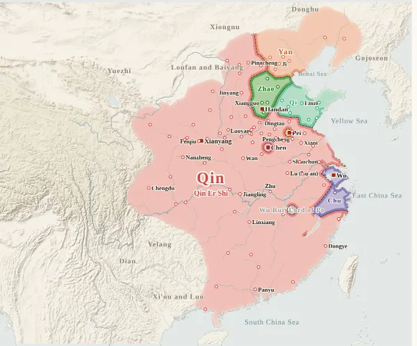
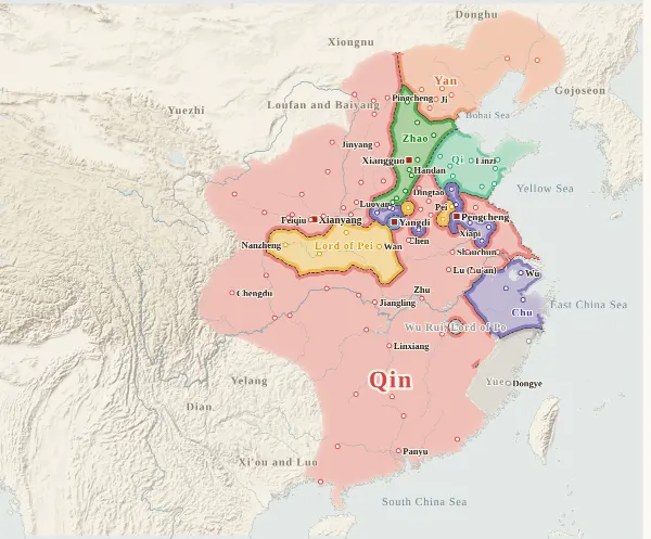
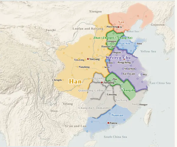
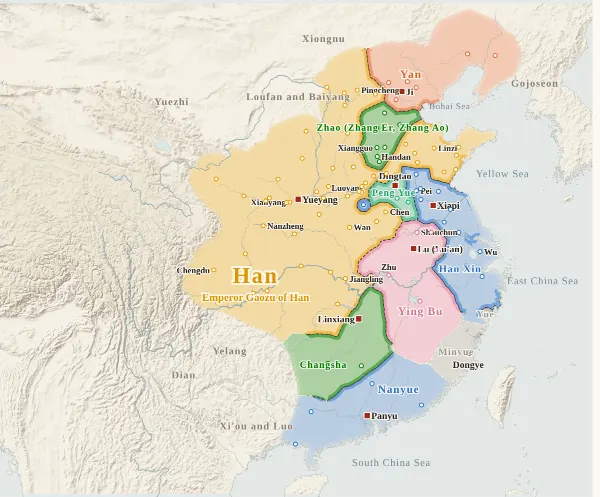
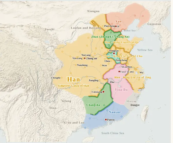
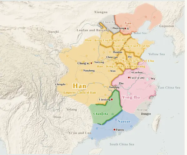
This map covers the fall of Qin, the Chu–Han contention between Xiang Yu and Liu Bang, and the beginning of Han. From 209 BC (the first year of the Second Emperor of Qin), when Chen Sheng and Wu Guang raised troops, to 195 BC, when Liu Bang died and Lu Wan, King of Yan, fled to the Xiongnu, it records who held each city at the end of every year, taken from the histories, and draws each power's territory from that. Move the year to watch the borders shift; click a city to see who held it, year by year, with the source passages.
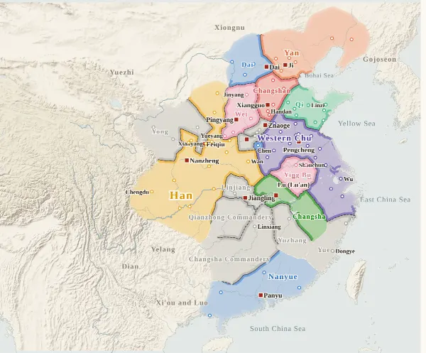
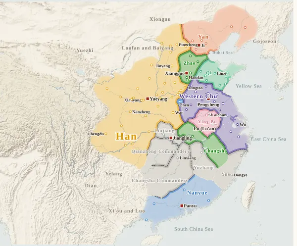
The map shows Qin, Chen Sheng's Zhang Chu, the revived kings of the six old states (Chu, Zhao, Qi, Yan, Wei and Hán, written with a different character from Han), the Eighteen Kings enfeoffed by Xiang Yu in 206 BC together with his own Western Chu, Han, the kings of other surnames in early Han (Han Xin, Peng Yue, Ying Bu, Zhang Er and Zhang Ao, Wu Rui and others), and Nanyue and Minyue, which held cities. Small states such as the Three Qins (Yong, Sai and Di), Yin, Henan, Linjiang and Minyue are grey, with their names on the map. The Xiongnu, Donghu, Yuezhi, Gojoseon and others appear only as names at the edge of the map.
The darker bands mark the borders between powers. Where the colour fades out, no city's control can be said to have reached (nomad lands, mountains), and no border is drawn. The red square marks each power's capital that year. The bands under the year slider have two rows: Qin and Han above, and the line of Chu below (Zhang Chu, the Chu of Xiang Liang and King Huai, and Xiang Yu's Western Chu); click one to jump to its first year.
Under each state's name is the emperor reigning at the end of that year. The Second Emperor of Qin was killed in the eighth month of 207 BC, and Ziying, who was set up after him, called himself King of Qin, not emperor, so no name appears under Qin at the end of 207 BC. Liu Bang became King of Han in 206 BC but took the throne as emperor only in 202 BC, when Xiang Yu fell, so no name appears under Han before then.
In the calendar of this period the year began with the tenth month and ended with the ninth (or the intercalary ninth month in years that had one). For example, “the tenth month, winter, of the first year of Han”, when Ziying, King of Qin, surrendered to Liu Bang, fell at the start of winter in 207 BC by today's calendar, but counts here as the beginning of 206 BC. Years follow the Zizhi Tongjian.
How this map was made
For 100 major cities, we took from the histories who held each one at the end of each year (whose king or commanding general was there) and attached the source passage to every change of hands. The main source is the Zizhi Tongjian, checked against the Records of the Grand Historian (Shiji) and the Book of Han: 941 passages on city holders in all, each machine-checked to appear word for word in the text, and, for the Zizhi Tongjian, to fall under the heading of the right year. Afterwards, separate checkers went over every line again against the text, region by region (7 regions), and corrected errors and omissions in 14 cities. Sieges and temporary occupations given up within the year do not change a city's holder.
Where the histories record that a king was replaced but say nothing city by city, as with Xiang Yu's enfeoffment (206 BC) and the Han reunification (202 BC), the cities of the commanderies granted are counted together as that king's. The kingdoms of kings of the Han imperial family (Liu Fei, King of Qi; Liu Jiao, King of Chu; Liu Heng, King of Dai; and others) are coloured as Han, with the king's name under the state name.
The borders are inferred by machine from who held the cities. The land is divided into 4 km squares, and each square is given to the power whose city can be reached from it with the least effort, allowing for steep mountains and the difficulty of crossing great rivers. Land far from every city (steppe, plateau, the lands of mountain peoples) is left uncoloured, with the colour fading out.
Where the cities of one power lie apart and its colour breaks off, they are joined by a band along a route that does not cross another power's land (up to about 400 km on level ground). Gaps surrounded on all sides by the powers' land and the sea, and gaps in the mountains south of the Qinling that reach deep into a power's land, are filled with the colour of the nearest power. Around cities that cannot be said to belong to anyone, however, the land is left blank even where a neighbouring power could reach it. A city surrounded by another power's land (an exclave) is drawn as a circle about 36 km in radius.
Borders at the time were zones rather than lines, and the lines on this map show only roughly where those zones lay.
Limits
- The texts do not say which king received Changsha Commandery, Qianzhong Commandery and Yuzhang in Xiang Yu's enfeoffment (206 BC). For 206–203 BC these three are coloured for no state and shown in grey under the commandery's name (a city's history marks them “inferred”). Giving Taiyuan and Shangdang to Western Wei and Ye to Changshan in the enfeoffment are likewise inferences without a passage naming them.
- In the years of the risings (209–207 BC), few records name individual cities, and much is inferred from the state of neighbouring commanderies. The year in which the northern edge of Yan and Dai (Shanggu, Yuyang, Youbeiping, Liaoxi, Liaodong, Yanmen, Yunzhong) broke away from Qin, the holders of Shouchun, Lu, Juchao and Guangling in Huainan, and which cities were the “twenty-odd cities of Wei” taken by Wei Bao after Zhang Han's surrender have not been confirmed.
- In the digital texts used, the body of the monthly table of the Qin–Chu transition and the table of the kings since the rise of Han in the Shiji and the Book of Han is omitted, so month-by-month changes of king are taken from the annals, hereditary houses and biographies.
- Where the histories disagree on a year, the Zizhi Tongjian is followed. Peng Yue's taking of the seventeen cities of Liang and Xiang Yu's recovery of them fall in the third year of Han (204 BC) in the Zizhi Tongjian but in the fourth year in the Shiji. Dai, Yanmen and Yunzhong were pacified after Chen Xi's rebellion in 195 BC according to the Zizhi Tongjian, while the Shiji makes Liu Heng King of Dai in the spring of 196 BC.
- The holders of Pingcheng, Shanwu and Yunzhong after King Xin of Hán went over to the Xiongnu (201 BC), the holders of Chen and Dang in 202 BC (the kingdom of Han Xin as King of Chu, or Han directly), and whether Minyue held Dong'ou cannot be settled from the texts.
- City dots are placed at the present-day city or county, not at the exact ancient site. Chang'an is shown from 200 BC, when Emperor Gaozu moved there from Yueyang and made it the capital. Nanyue and Minyue have few cities, and how far their control actually reached is hard to decide from the histories.
- Coastlines and most rivers are modern. The lower Yellow River is drawn as a rough line through points it passed at the time, following its course under Qin and Former Han (through Guantao and Qinghe to the sea near Zhangwu in Bohai Commandery, according to the treatise on geography of the Book of Han). Its lower course differs from that on the other maps, which show the river after the Later Han flood works.
- Qin and Han use the site's dynasty colours; the others have colours of their own on this map. With too few colours, states whose years do not overlap or that lie far apart sometimes share one (red for Qin and Changshan; pink for Zhang Chu, Wei and Ying Bu; green for Zhao and Changsha; blue for Dai, Han Xin, Hán and Nanyue; teal for Qi and Peng Yue): tell them apart by name. Chu and Western Chu, and the Lord of Pei and Han, share colours because they were one house.
Sources and licences
- Texts of the histories: the Daizhige (殆知閣) digital texts (quotations kept in simplified characters): the Zizhi Tongjian, the Shiji and the Book of Han
- Coastlines, rivers and lakes: Natural Earth (public domain)
- Relief shading: NOAA ETOPO1 (public domain)
Japanese version
The Japanese version of this map also shows what happened each year, notes on every uncertain point, and the source passages (in Classical Chinese) for each change of hands: 楚漢〜前漢初の勢力図.