Map of the Northern and Southern Dynasties
420–589 · About this map
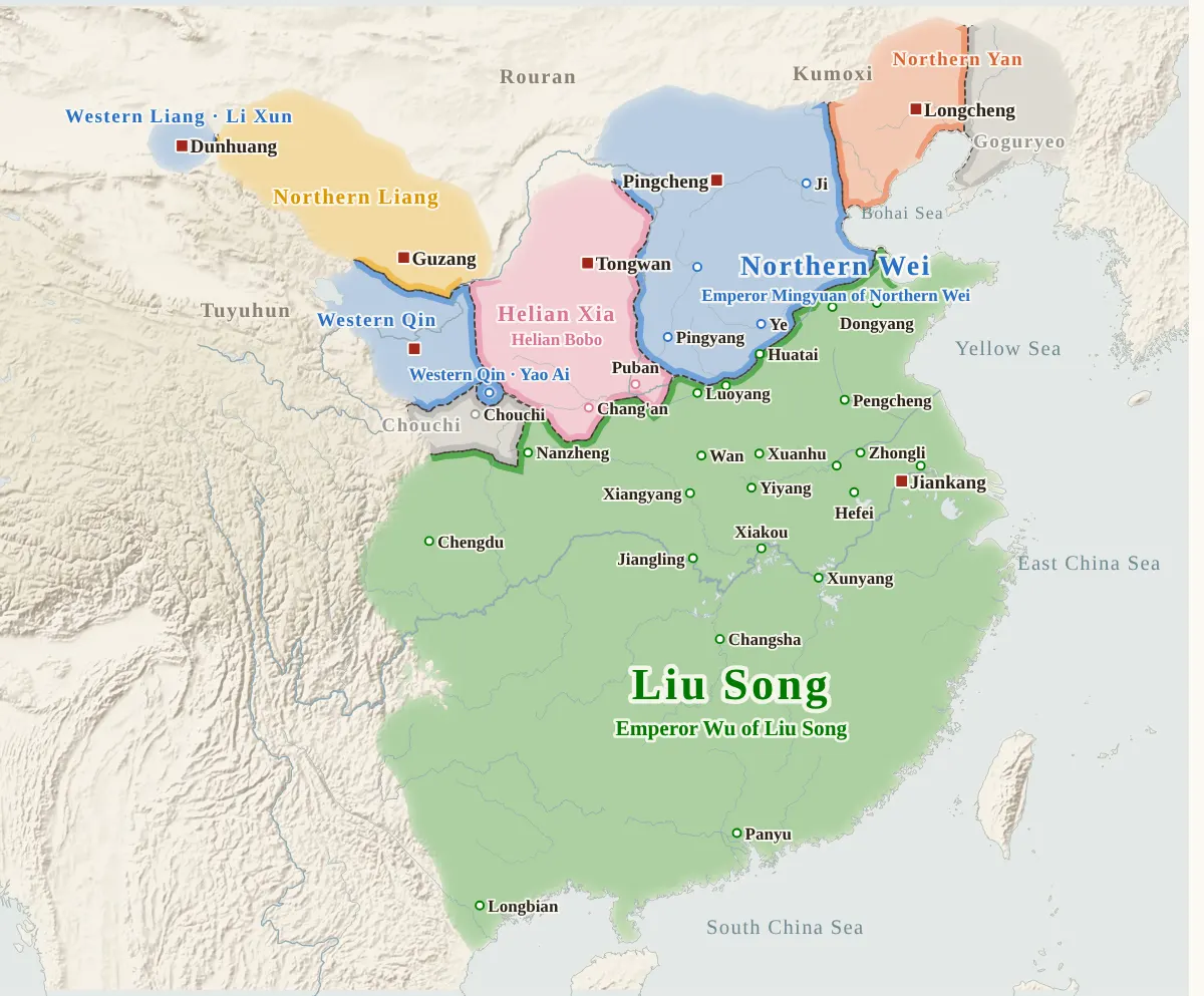
Loading the map…
420
Key year: Liu Song founded
This year
Tap a city on the map, or a city name below, to see who held it year by year. Pinch or tap + to zoom in and see the smaller cities.
Dynasties on this map
- Liu Song宋420–479 · 8 rulers · Emperor Wu of Liu Song to Emperor Shun of Liu SongLiu Yu, who had won distinction in battle during the rebellion of Sun En, raised troops at Jingkou in 404 and overthrew Huan Xuan, who had usurped the imperial throne; he attacked Southern Yan and captured Murong Chao, and he attacked Later Qin and entered Chang'an in 417.Emperors in orderRise and fall
- Southern Qi齊479–502 · 7 emperors · Emperor Gao of Southern Qi to Emperor He of Southern QiXiao Daocheng, who had fought the rebels in the east of Liu Song in 466, defeated Liu Xiufan, Prince of Guiyang, at Xinting in 474, and when Emperor Houfei of Liu Song was killed in 477, he brought in Emperor Shun of Liu Song and set him up, and took control of the government of Liu Song.Emperors in orderRise and fall
- Liang梁502–560 · 5 rulers · Emperor Wu of Liang to Emperor Jing of LiangXiao Yan, whose eldest brother Xiao Yi had been killed by Xiao Baojuan of Southern Qi, raised troops at Xiangyang in 500 and joined with Xiao Yingzhou of Jing Province.Emperors in orderRise and fall
- Western Liang西梁555–587 · 3 emperors · Emperor Xuan of Western Liang to Xiao CongXiao Cha, a son of Crown Prince Zhaoming of Liang, had become the enemy of his uncle Xiao Yi, Prince of Xiangdong (Emperor Yuan of Liang), and fearing that he could not hold his own, in 549 he declared himself a vassal of Western Wei, and the next year he was invested as Prince of Liang.Emperors in orderRise and fall
- Chen陳557–589 · 5 emperors · Emperor Wu of Chen to Chen ShubaoChen Baxian, a man of Changcheng in Wuxing, swore an alliance with Wang Sengbian in 552 and crushed the army of Hou Jing, and in 555 Chen Baxian opposed Wang Sengbian's setting up of Xiao Yuanming, whom Northern Qi had sent, as emperor, and quarreled with him.Emperors in orderRise and fall
- Northern Wei北魏399–535 · 12 rulers · Emperor Daowu of Northern Wei to Emperor Xiaowu of Northern WeiAfter the people of the state of Dai were scattered by the invasion of Fu Jian, Tuoba Gui, a grandson of Emperor Zhaocheng, took the position of King of Dai at Niuchuan in 386, and within the same year changed his title to King of Wei.Emperors in orderRise and fall
- Northern Qi北齊550–580 · 6 rulers · Emperor Wenxuan of Northern Qi to Gao HengIn the family of Gao Huan, who had set up the emperor of Eastern Wei and moved the capital to Ye, the elder brother Gao Cheng was killed in 549, and the younger brother Gao Yang then went to Jinyang and took overall charge of the government.Emperors in orderRise and fall
- Western Wei西魏535–557 · 3 emperors · Emperor Wen of Western Wei to Emperor Gong of Western WeiIn 534 Emperor Xiaowu of Northern Wei, at odds with Gao Huan, fled into Guanzhong, was received by Yuwen Tai and entered Chang'an, but he died at the end of that year.Emperors in orderRise and fall
- Northern Zhou北周559–581 · 5 rulers · Yuwen Jue to Emperor Jing of Northern ZhouIn 556 Yuwen Tai, who had held real power in Western Wei, died, and his son Yuwen Jue succeeded him as Grand Preceptor and Chief Minister, and early in 557 Yuwen Jue received the throne from Emperor Gong of Western Wei.Emperors in orderRise and fall
Also on this map: Han (Hou Jing), Eastern Wei
How the period unfolded
Song and N. Wei420–493
Qi, Liang, N. Wei494–533
Wei splits534–556
N. Qi and N. Zhou557–580
Sui reunifies581–589
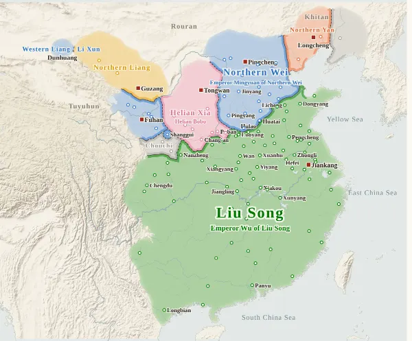
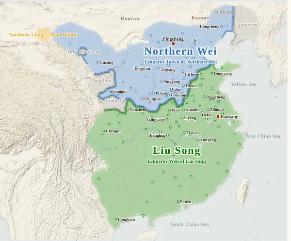
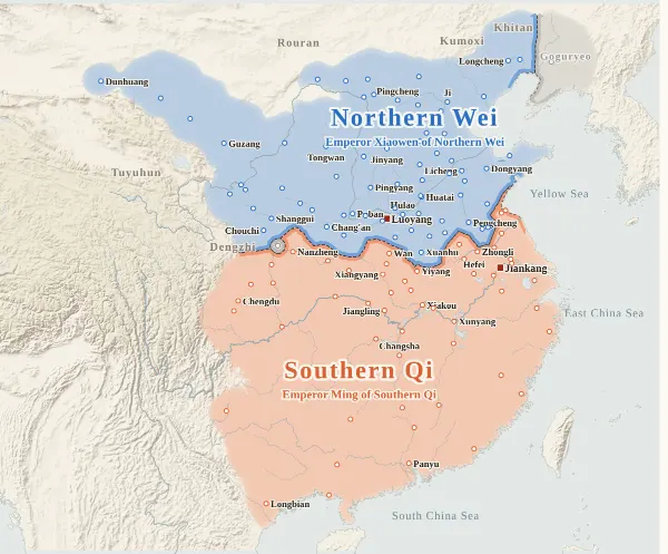
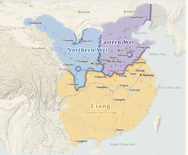
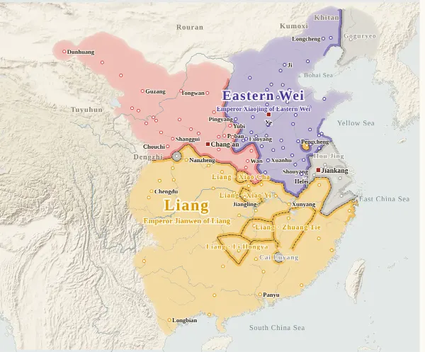
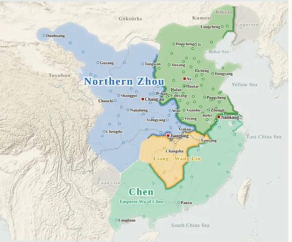
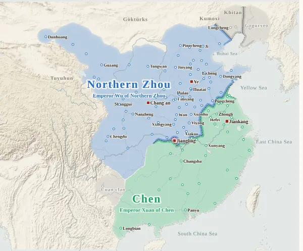
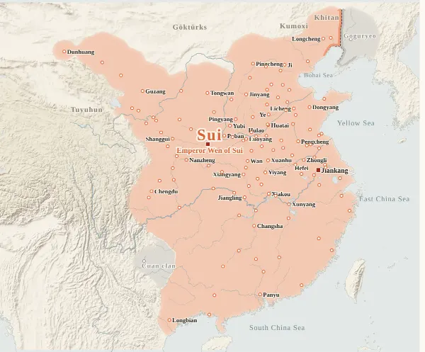
About this map
This map covers the years from the founding of Liu Song in 420 to the Sui reunification in 589. For every year it records which dynasty held each major city at the end of the year, taken from the histories, and draws each dynasty's territory from that. Move the year to watch the borders shift; click a city to see who held it, year by year. The years 420–439 overlap the Sixteen Kingdoms map, and for those twenty years both maps use the same cities, the same holders and the same drawing method, so the same year gives the same map.
The darker bands mark the borders between dynasties. Where the colour fades out, no city's control can be said to have reached (nomad lands, mountains), and no border is drawn. The red square marks the city where an emperor or king was at the end of the year. The bands under the year slider show the Northern Dynasties on the upper row (split into two rows while Eastern and Western Wei were divided) and the Southern Dynasties on the lower row; click one to jump to that dynasty's first year.
How this map was made
For 130 major cities, we took from the histories which dynasty's inspector, governor or commanding general was there at the end of each year, and attached the source passage to every change of hands. Cities are not shown for years before their walls or garrisons existed: the Six Garrisons appear from the year each garrison was set up, and Yubi from 538, when it was built. The main source is the Zizhi Tongjian, checked against the Book of Song, the Book of Southern Qi, the Book of Liang, the Book of Chen, the Book of Wei, the Book of Northern Qi, the Book of Zhou, the Book of Sui, the History of the Southern Dynasties and the History of the Northern Dynasties: 695 passages for the years a city changed hands, each machine-checked to appear word for word in the text. Sieges and occupations given up within the year do not change a city's holder.
The borders are inferred by machine from who held the cities. The land is divided into 4 km squares, and each square is given to the dynasty whose city can be reached from it with the least effort, allowing for steep mountains and the difficulty of crossing great rivers. Land far from every city (steppe, plateau, the lands of upland peoples) is left uncoloured, with the colour fading out.
Where the cities of one dynasty lie apart and its colour breaks off, they are joined by a band along a route that does not cross another dynasty's land (up to about 400 km on level ground), on the view that the dynasty kept the road between its cities open. Gaps surrounded on all sides by the dynasties' land and the sea, and gaps in the mountains south of the Qinling that reach deep into a dynasty's land (today's Guizhou, western Hunan and so on, the lands of the peoples called Man and Liao), are filled with the colour of the nearest dynasty. A city surrounded by another dynasty's land (an exclave) is drawn as a circle about 36 km in radius, since dividing the land halfway between cities would make an exclave look larger than it was. Commanderies and counties also lay inside that circle, but with no city dot on the map for them, control there is shown more thinly than around the cities.
Borders at the time were zones rather than lines, and the lines on this map show only roughly where those zones lay.
Limits
- Most changes of hands were checked against the text, but 42 changes are inferred from the surrounding entries because no passage was found (marked “inferred” in a city's history). For some changes only the year is inferred (“Year estimated”).
- City dots are placed at the present-day city or county, not at the exact ancient site. The identifications follow Hu Sanxing's commentary.
- For Xiping and Ledu (in today's eastern Qinghai), no passage was found saying whether Northern Wei or the Tuyuhun held the cities from 439, when Northern Liang fell, to 530, so for those years the dots are not shown and the area is left uncoloured.
- Frontier regions such as the land of the Six Garrisons, Ning Province (today's Yunnan) and Jiao Province (northern Vietnam) are places where the histories do not make clear how far control actually reached.
- Coastlines and most rivers are modern. Only the lower Yellow River (its course from the Later Han on), the lower Huai (before Hongze Lake formed), the Si and the Luo are redrawn as rough lines through points they passed at the time. The coast of northern Jiangsu lies further east today than it did then.
- Western Liang (the Liang at Jiangling) is drawn with the single city of Jiangling. The Zizhi Tongjian records that in 571 it borrowed the three provinces of Ji, Ping and Ruo (around today's Dangyang and Jingmen in Hubei) from Northern Zhou, but they are not among the city dots, so Western Liang appears smaller than it was.
- In the site's dynasty colours, Northern Zhou and Sui share Chen's blue-green and could not be told apart from neighbouring Chen, so on this map alone Northern Zhou is blue and Sui orange (blue is Northern Wei's colour and orange Southern Qi's, but neither overlaps in time). Northern Liang, Northern Yan, Western Liang (the Sixteen Kingdoms state, not the Liang at Jiangling) and Western Qin have the same colours as on the Sixteen Kingdoms map, which overlaps in 420–439 (Western Qin and Western Liang are the same blue as Northern Wei, but their lands did not touch).
Sources and licences
- Texts of the histories: the Daizhige (殆知閣) digital texts (quotations kept in simplified characters)
- Coastlines, rivers and lakes: Natural Earth (public domain)
- Relief shading: NOAA ETOPO1 (public domain)
- Other map data used for comparison: Seshat Global History Databank, “Cliopatria” (CC BY 4.0). Its time steps are coarse, and it is not built into this map.
Japanese version
The Japanese version of this map also shows what happened each year, notes on every uncertain point, and the source passages (in Classical Chinese) for each change of hands: 南北朝の勢力図.