Map of the Qing Dynasty
1684–1911 · About this map
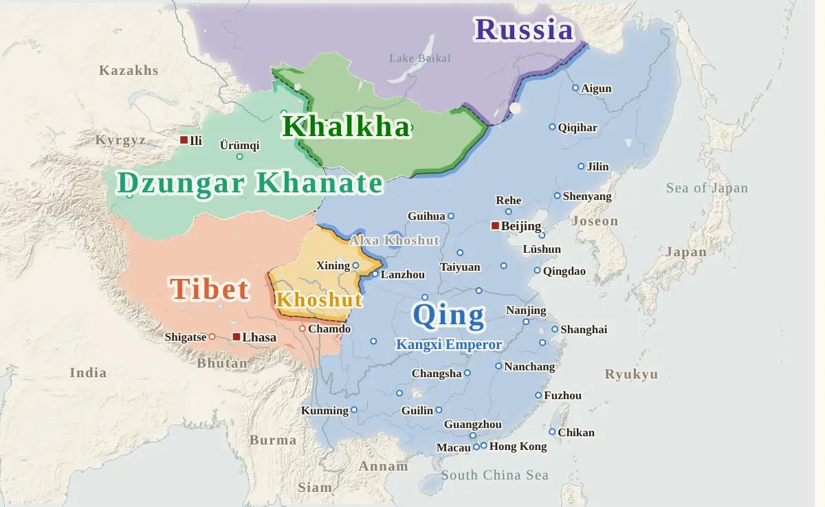
Loading the map…
1684
This year
Tap a city on the map, or a city name below, to see who held it year by year. Pinch or tap + to zoom in and see the smaller cities.
How the period unfolded
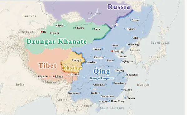
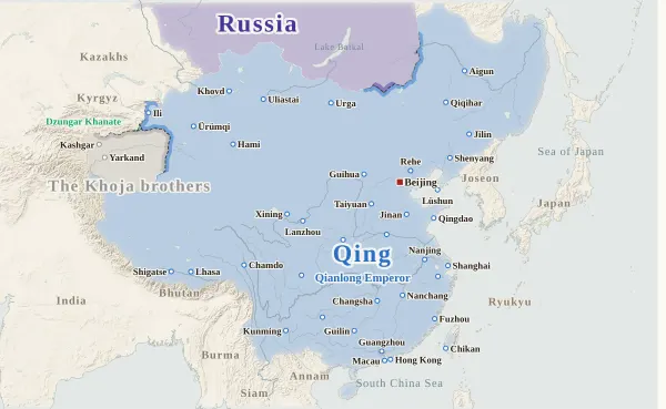
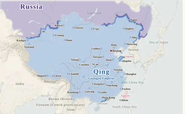
Expansion1684–1758
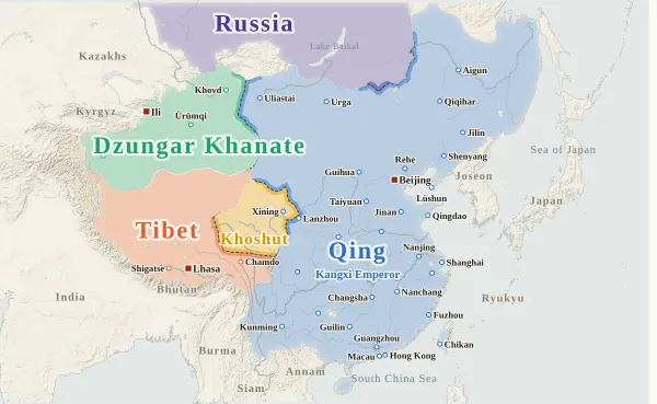
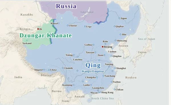
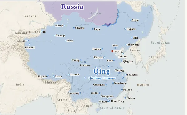
Greatest extent1759–1841
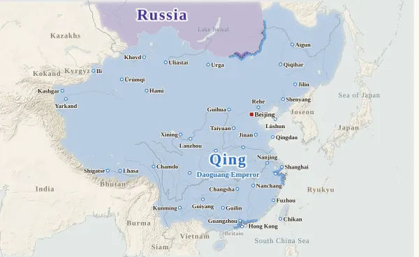
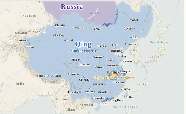
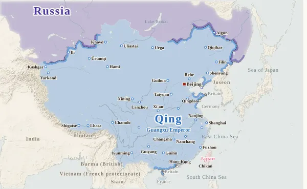
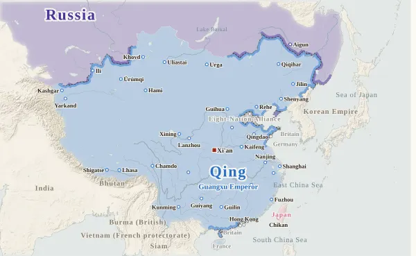
Wars and treaties1842–1897
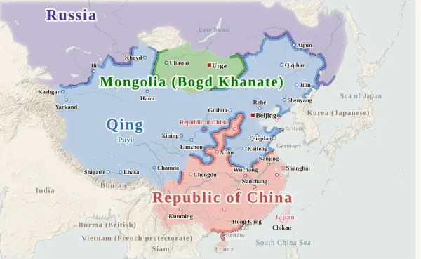
Fall of Qing1898–1911
Emperors of the Qing period
Each dynasty's page lists its emperors with their reigns and causes of death.
About this map
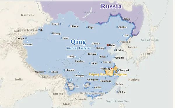
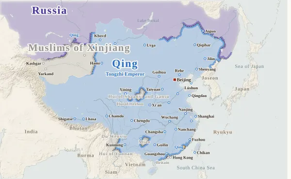
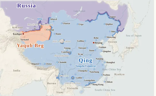
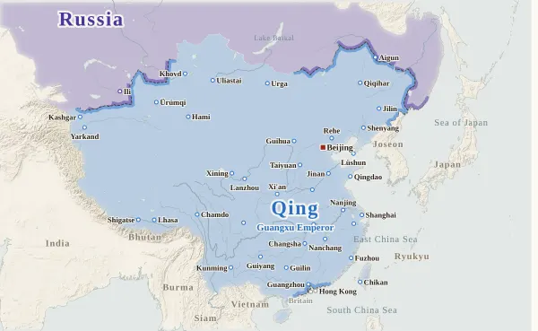
This map covers the years from 1684 (the 23rd year of Kangxi), the year after the Zheng clan on Taiwan surrendered to the Qing, to the revolution of 1911 (the 3rd year of Xuantong). For every year it records who held each city and place at the end of the year, taken from the histories, and draws each power's territory from that. It continues the map of the Ming–Qing transition. Move the year to watch the borders shift; click a city to see who held it, year by year.
The coloured powers are the Qing; the Dzungars, Khalkha, the Khoshut (in Qinghai) and Tibet outside it; the Taiping Heavenly Kingdom and Yaqub Beg, which rose from within it; Mongolia (the Bogd Khanate) and the Republic of China in 1911; and Russia, Britain, Japan, Germany, France and Portugal, which took territory. Other risings — the Hui, Du Wenxiu, Jahangir Khoja and others — are grey, with their names. Joseon, Vietnam, Burma and other neighbours appear only as names at the edges of the map.
Mongolia, Qinghai, Tibet and Xinjiang take the Qing colour from the year they submitted to the Qing, or the year the Qing stationed a general or an imperial resident there. Even where the Dalai Lama's government or the Mongol banners governed their own land, it is coloured as Qing territory for as long as Qing officials were posted there.
Click the gear at the bottom right of the map and turn on “Show modern cities” to see provincial capitals and other cities of today. Type a modern name such as “Shanghai” into “Find by modern name” under the same gear to open the city at that place.
Years follow the years of the Qing calendar. Events of the twelfth month count in that year, though by the modern calendar they may fall in January or February of the next. Only the last year, 1911, is different: the end of that year in the Qing calendar (February 1912 by the modern calendar) comes after the abdication of the Xuantong emperor, so the map shows the situation on 31 December 1911 by the modern calendar.
How this map was made
For 278 major cities and frontier places, we took from the histories who held each one at the end of each year, and attached the source passage to every change of hands. The main source is the Draft History of Qing (the basic annals, the treatises on geography and on foreign relations, the accounts of the dependencies and the biographies), checked against the Veritable Records of the Qing (Xianfeng, Tongzhi, Guangxu and Xuantong), the Qinding Waifan Menggu Huibu Wanggong Biaozhuan and the Taiwan Tongshi: 635 passages in all, each machine-checked to appear word for word in the text. Sieges and occupations given up within the year do not change a city's holder (such as the cities the Taiping Northern Expedition passed through). Land ceded by treaty and leased territories take the other country's colour from the year the treaty was signed.
The borders are inferred by machine from who held the cities. The land is divided into 4 km squares, and each square is given to the power whose city can be reached from it with the least effort, allowing for steep mountains and the difficulty of crossing great rivers. Land far from every city is left uncoloured and fades out. The Mongolian steppe and the plateaus of Qinghai and Tibet have few cities, so places there are coloured out to about 480 km on level ground, and the oasis cities of Xinjiang out to about 420 km.
Siberia (the part of today's Russia west of the Argun River) is Russian in every year. Today's Kazakhstan and Kyrgyzstan take the Russian colour from 1864, when Russia took the cities there, and have no colour before that. The land of other present-day countries such as Korea and Vietnam is not coloured.
Where the cities of one power lie apart and its colour breaks off, they are joined by a band along a route that does not cross another power's land (up to about 400 km on level ground). A city surrounded by another power's land (an exclave) is drawn as a circle about 36 km in radius.
The Yellow River is drawn on its old course through Xuzhou and Huai'an to the Yellow Sea before the breach at Tongwaxiang in 1855 (the 5th year of Xianfeng), and on its present course through Shandong to the Bohai Sea from 1855.
Borders at the time were zones rather than lines, and the lines on this map show only roughly where those zones lay.
Limits
- For the end of 1911, the histories record when each province's capital broke away from the Qing (declared independence), but for many of the other cities in a province they give no date, so 91 places follow their provincial capital into the Republic of China's colour (a city's history shows “Inferred”). The Republic of China was founded on 1 January 1912; at the end of 1911 the military governments of the provinces had not yet become one government.
- The Draft History of Qing puts Yaqub Beg's capture of the cities of southern Xinjiang all together under the 3rd year of Tongzhi (1864), with no year for each city. Kashgar and Yengisar are placed in 1865, Yarkand in 1866, and Khotan, Aksu, Ush, Kucha and Karashahr in 1867 (a city's history shows “Year estimated”).
- Tibet takes the Qing colour from 1720, when Qing troops entered Lhasa. The Dalai Lama's government ruled Tibet, while the Qing posted imperial residents (amban) and kept troops there, so how much of it should count as Qing territory is still debated.
- North of the Amur and on the Ussuri coast (Boli, Miaojie, Haishenwai and others), in Outer Mongolia just after Khalkha submitted to the Qing, in newly submitted cities of Xinjiang and elsewhere, there are years with no Qing officials yet in place; for these a city's history shows “nominal”.
- City dots are placed at the present-day city or county, not at the exact ancient site. For Mongolia, Qinghai and Tibet, the places chosen are the centres of leagues and banners, monasteries, and the seats of resident officials.
- Coastlines and rivers, except the lower Yellow River, are modern.
- The Qing uses the site's dynasty colour; the others have colours of their own on this map. Powers that share a colour never appear in the same year.
Sources and licences
- Texts of the histories: the Daizhige (殆知閣) digital texts (quotations kept in simplified characters): the Draft History of Qing, the Veritable Records of the Qing (Xianfeng, Tongzhi, Guangxu and Xuantong), the Qinding Waifan Menggu Huibu Wanggong Biaozhuan and the Taiwan Tongshi
- Coastlines, rivers, lakes, modern cities and provincial borders: Natural Earth (public domain)
- Relief shading: NOAA ETOPO1 (public domain)
Japanese version
The Japanese version of this map also shows what happened each year, notes on every uncertain point, and the source passages (in Classical Chinese) for each change of hands: 清の勢力図.