Map of the Three Kingdoms
190–280 · About this map
Loading the map…
190
This year
Tap a city on the map, or a city name below, to see who held it year by year.
Emperors of the Three Kingdoms and Eastern Han periods
26 rulers claimed the title of emperor in these periods. Each dynasty's page lists its emperors with their reigns and causes of death.
About this map
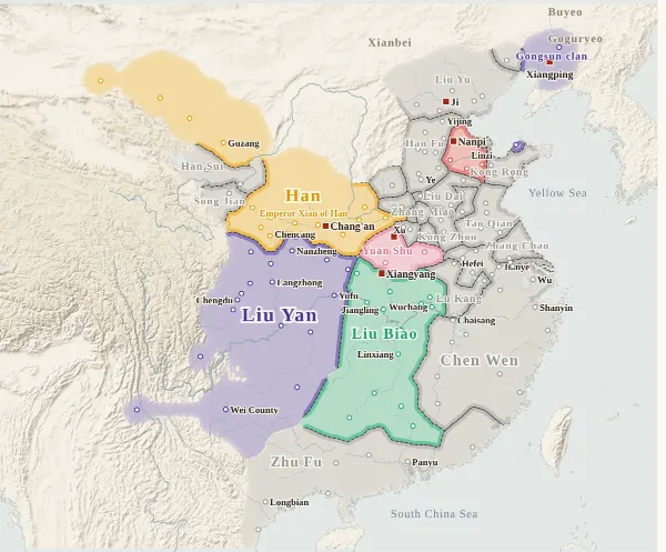
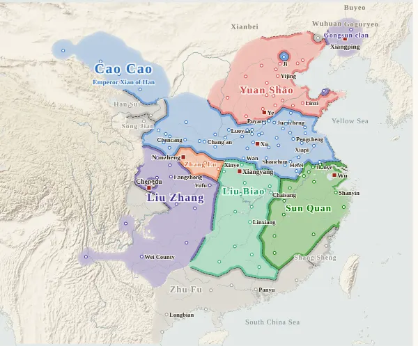
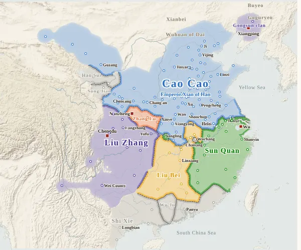
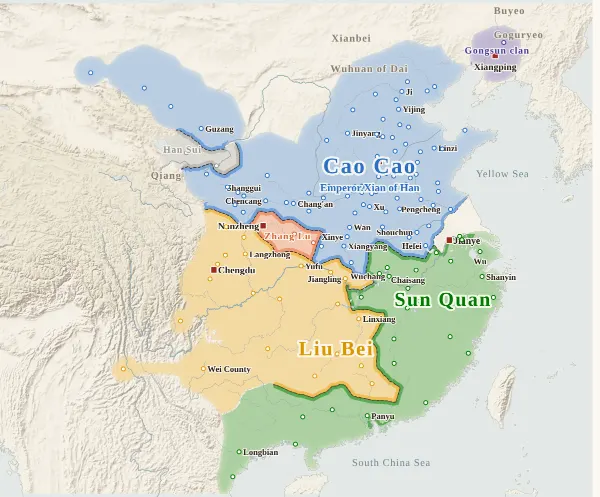
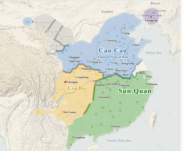
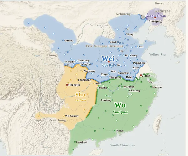
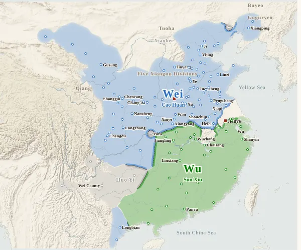
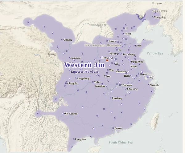
This map covers the Three Kingdoms era from 190, when Dong Zhuo moved the capital to Chang'an and the eastern provinces raised troops against him, to 280, when Jin conquered Wu and reunited China. For every year it records who held each major city at the end of the year, taken from the histories, and draws each power's territory from that. Move the year to watch the borders shift; click a city to see who held it, year by year.
Until 220 the only emperor was Emperor Xian of Han. The map labels the area held directly by his court around Chang'an in 190–195 as “Han”, and the territory of Cao Cao, who brought Emperor Xian to Xu in 196, as “Cao Cao”, with Emperor Xian's name beneath it. Cao Cao, Liu Bei and Sun Ce and Sun Quan are drawn in the colours of the later Wei, Shu and Wu.
The darker bands mark the borders between powers. Where the colour fades out, no city's control can be said to have reached (steppe, mountains), and no border is drawn. The red square marks each power's seat that year. The bands under the year slider show, from the top, the north (the Han court, Wei, Western Jin), Liu Bei and Shu, and the Sun family and Wu; click one to jump to its first year. The warlords are not shown in the bands.
Under each state's name is the emperor reigning at the end of that year. Liu Bei claimed the title in 221 and Sun Quan in 229, so their names do not appear before then. Yuan Shu claimed it in 197 and died in 199. “The end of the year” is the last day of the Chinese calendar year: Emperor Yuan of Wei abdicated in the twelfth month of the second year of Xianxi, which fell in February 266 by the Western calendar but counts here as the end of 265.
How this map was made
For 138 major cities, we took from the histories who held each one at the end of each year (whose inspector, governor or commanding general was there) and attached the source passage to every change of hands. The main source is the Zizhi Tongjian, checked against the Records of the Three Kingdoms, the Book of the Later Han and the Book of Jin: 1,063 passages in all, each machine-checked to appear word for word in the text. Sieges and occupations that were given up within the year (such as Tianshui, Nan'an and Anding, which went over to Zhuge Liang in 228 and soon returned to Wei) do not change a city's holder. Years in which a city cannot be said to belong to anyone (Luoyang after Dong Zhuo burned it, cities north of the Yangtze emptied of their people) are left uncoloured.
In the warlord years, where a provincial governor held his province, all its cities are counted as his; a commandery administrator is shown under his own name only when he acted independently of the province. Small powers (Tao Qian, Zhang Yang, Zhang Xiu, Liu Yao, Ma Teng, Han Sui, Shi Xie and others) are grey, with their names on the map.
The borders are inferred by machine from who held the cities. The land is divided into 4 km squares, and each square is given to the power whose city can be reached from it with the least effort, allowing for steep mountains and the difficulty of crossing great rivers. Land far from every city (steppe, plateau, the uplands of non-Han peoples) is left uncoloured.
Where the cities of one power lie apart, they are joined by a band along a route that does not cross another power's land (up to about 400 km on level ground). Gaps surrounded on all sides by the powers' land and the sea, and gaps in the mountains south of the Qinling that reach deep into a power's land (today's Guizhou, western Hunan and so on), are filled with the colour of the nearest power, except around cities that cannot be said to belong to anyone. A city surrounded by another power's land (an exclave) is drawn as a circle about 36 km in radius.
Borders at the time were zones rather than lines, and the lines on this map show only roughly where those zones lay.
Limits
- In the warlord years of 190–196, few records name who held individual cities, so many are inferred from the provincial governor or from the warlords contending for the province (Yu, Qing and Jiao provinces, and Yang Province south of the Yangtze).
- Some distant regions that acknowledged a power only in name are coloured for that power (marked “nominal” in a city's history): the part of Yang Province south of the Yangtze under Chen Wen (190–191), Liang Province and the Hexi Corridor (the Han court in 190–195, Cao Cao from 196; in practice Ma Teng, Han Sui and local magnates held power), and Jiao Province under Shi Xie (Sun Quan) from 210.
- Three changes are placed without a passage naming the city (marked “inferred”). Where the histories disagree on a year, the Zizhi Tongjian is followed.
- After Liu Shan surrendered in 263, Huo Yi in Nanzhong and Luo Xian at Yong'an (Baidi) had not yet submitted to Wei by the end of the year, so on the 263 map those cities alone remain grey.
- City dots are placed at the present-day city or county, not at the ancient site. Northern frontier areas (Yunzhong, Yanmen, Liucheng), Nanzhong (today's Yunnan and Guizhou) and Jiao Province (northern Vietnam) are places where the histories do not make clear how far control actually reached.
- Coastlines and most rivers are modern. Only the lower Yellow River, the lower Huai, the Si and the Luo are redrawn as rough lines through points they passed at the time.
- Wei, Shu, Wu and Western Jin use the site's dynasty colours; the warlords have colours of their own on this map. With too few colours, some warlords far apart share one (Gongsun Zan and Liu Biao, Lü Bu and Zhang Lu, Liu Zhang and the Gongsun clan of Liaodong): tell them apart by name. Cao Cao and Wei, Liu Bei and Shu, Sun Ce, Sun Quan and Wu, Liu Yan and Liu Zhang, and Yuan Shao and his sons share colours because they were one family.
Sources and licences
- Texts of the histories: the Daizhige (殆知閣) digital texts (quotations kept in simplified characters)
- Coastlines, rivers and lakes: Natural Earth (public domain)
- Relief shading: NOAA ETOPO1 (public domain)
Japanese version
The Japanese version of this map also shows what happened each year, notes on every uncertain point, and the source passages (in Classical Chinese) for each change of hands: 三国の勢力図.