Map of Song, Liao, Jin and Western Xia
960–1279 · About this map
Loading the map…
960
This year
Tap a city on the map, or a city name below, to see who held it year by year.
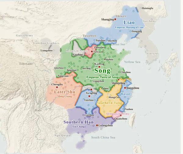
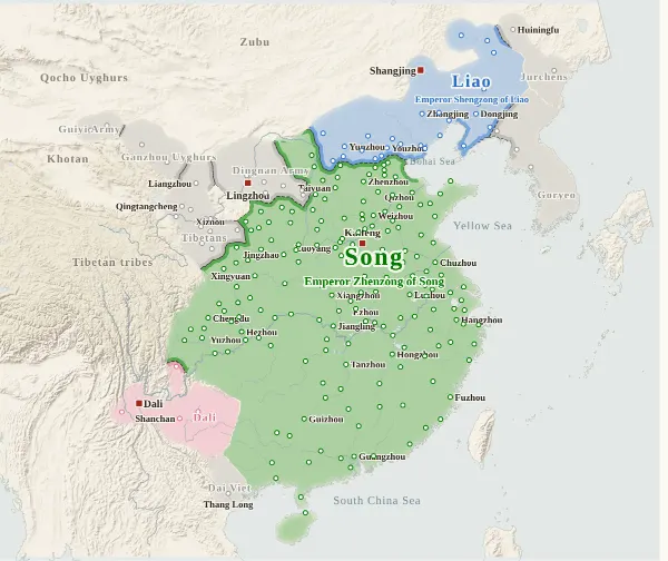
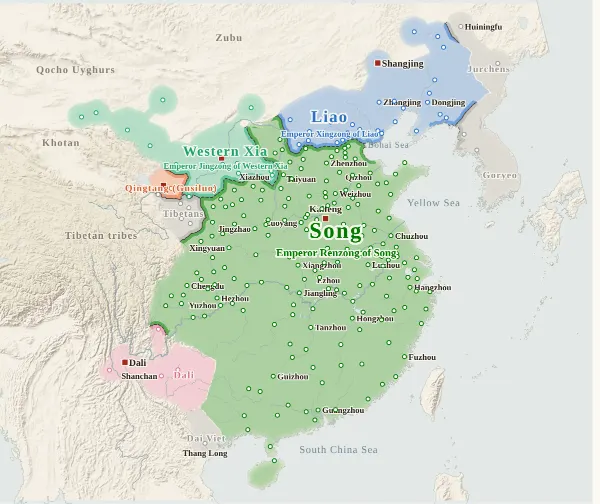
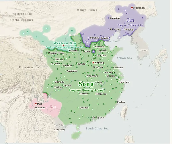
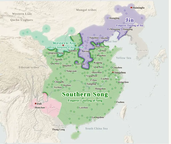
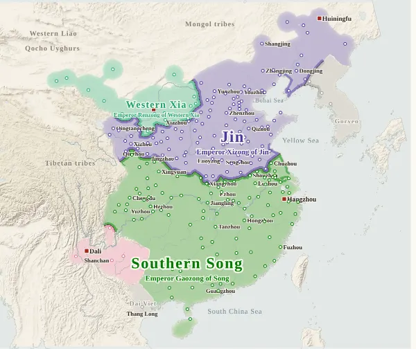
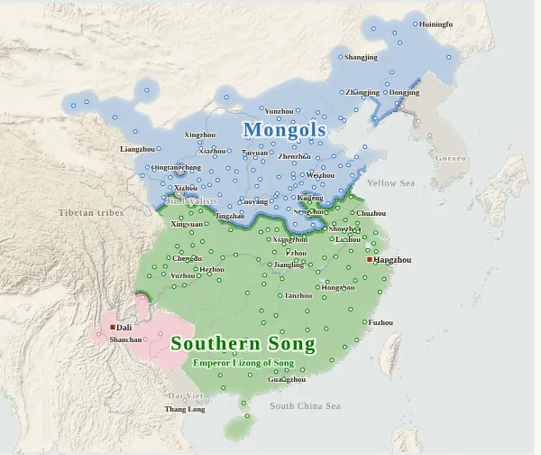
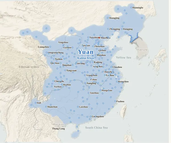
Emperors of the Song and Liao, Western Xia and Jin and Yuan periods
70 rulers claimed the title of emperor in these periods. Each dynasty's page lists its emperors with their reigns and causes of death.
About this map
This map covers China from 960, when Zhao Kuangyin founded the Song, to 1279, when the Southern Song fell at the Battle of Yamen. For every year it records who held each city at the end of the year, taken from the histories, and draws each power's territory from that. Move the year to watch the borders shift; click a city to see who held it, year by year, with the source passages.
Besides Song (Northern and Southern), Liao, Jin, Western Xia and the Mongols (Yuan from 1271), the map shows every state and power that held cities. Dali in Yunnan, Gusiluo's Qingtang, the Qi of Liu Yu set up by Jin, the Eastern Xia of Puxian Wannu, who made himself independent in Liaodong in the last years of Jin, and others are drawn in colour. Powers that briefly held cities, such as the warlords of the years when Jin replaced the Northern Song (Li Cheng, Kong Yanzhou, Sang Zhong and others) and Li Quan in Shandong and northern Huai in the last years of Jin, are grey, with only their names. Western Liao, the Qocho Uyghurs and others lie beyond the map, so only their names are placed at its edge.
The darker bands mark the borders between powers. Where the colour fades out, no city's control can be said to have reached (nomadic lands, mountains), and no border is drawn. The red square marks each power's capital that year. The bands under the year slider show, from the top, Song, the northern dynasties (Liao, Jin, the Mongols, Yuan) and the Li family of Xiazhou (the Dingnan Army, then Western Xia); click one to jump to its first year.
Under each state's name is the emperor reigning at the end of that year. For the Mongols, names start with Kublai (Shizu, enthroned in 1260): the rulers from Genghis Khan to Möngke are not in the site's list of emperors, so their names do not appear. “The end of the year” is the last day of the Chinese calendar year: Emperor Huizong handed the throne to Emperor Qinzong in the twelfth month of the seventh year of Xuanhe, which fell in January 1126 by the Western calendar but counts here as the end of 1125.
The years 960–979 overlap with the Five Dynasties and Ten Kingdoms map. For these 20 years, so that both maps show the same cities, the same holders and the same colours, the research for the Five Dynasties map (which traced the prefectures of the Ten Kingdoms one by one) is used as it is. Cities found only on this map appear from 980. (There are 39 cities found only on the Five Dynasties map, so this map has 280 cities in all.)
How this map was made
For 241 major cities, we took from the histories who held each one at the end of each year (whose prefect or commanding general was there) and attached the source passage to every change of hands. The main source is the Xu Zizhi Tongjian, with the Xu Zizhi Tongjian Changbian for the first half of the Song, the Jianyan Yilai Xinian Yaolu for the years of the wars between Song and Jin, and checks against the Histories of Song, Liao, Jin and Yuan. From 980 there are 1,281 passages in all, each machine-checked to appear word for word in the corresponding line of the text, and, for the Xu Zizhi Tongjian, to fall under the heading of the right year. After this, separate reviewers went back over every line against the text for each of 15 regions and corrected errors and omissions in 74 places. Sieges and occupations that were given up within the year do not change a city's holder.
In years when one dynasty replaced another (1127, Northern Song to Southern Song; 1137, when Qi was abolished and Jin ruled directly; 1271, when the Mongols took the dynastic name Yuan), every city held by the old dynasty at the end of the previous year is passed as a whole to the new one (a change is entered for that year even where there is no passage for the individual city). The Li family of Xiazhou is shown as the Dingnan Army (grey) before 1038, when Li Yuanhao proclaimed himself emperor, and as Western Xia from 1038.
The borders are inferred by machine from who held the cities. The land is divided into 4 km squares, and each square is given to the power whose city can be reached from it with the least effort, allowing for steep mountains and the difficulty of crossing great rivers. Land far from every city (steppe, plateau, the lands of upland peoples) is left uncoloured, with the colour fading out. The surroundings of cities that cannot be said to belong to anyone (ruined and abandoned) are not coloured either.
Where the cities of one power lie apart and its colour breaks off, they are joined by a band along a route that does not cross another power's land (up to about 400 km on level ground). Gaps surrounded on all sides by the powers' land and the sea, and gaps in the mountains south of the Qinling that reach deep into a power's land, are filled with the colour of the nearest power. A city surrounded by another power's land (an exclave) is drawn as a circle about 36 km in radius.
Borders at the time were zones rather than lines, and the lines on this map show only roughly where those zones lay.
Limits
- Seven changes have no passage stating directly that the city changed hands, and their years are inferred from the entries before and after (marked “inferred” when you click a city): the year Bazhou finally passed to the Mongols (1220), the year Sizhou returned to Song after Jin withdrew (1135), the year Suizhou, lost to Qi, returned to Song (1139), the year Jin retook Jinzhou (錦州) (1217), the year Eastern Xia took Huiningfu (the Jin Upper Capital) (1219), the year Huazhou is taken to have passed to Jin along with the fall of Chang'an (1129), and the year Jinzhou (金州) surrendered to Yuan (1279).
- Where the histories disagree on a year, the Xu Zizhi Tongjian is followed. For example, Zhe Keqiu of Fuzhou surrendered to Jin in 1128 according to the Xu Zizhi Tongjian and in 1129 according to the History of Jin. Changes that the Xu Zizhi Tongjian does not record follow the years in the Histories of Song, Jin and Yuan.
- Xiangyang, after Song retook it in 1239, was in fact abandoned for a time until 1251, when it was reported as “積年委棄、一旦收復” (left abandoned for years, now recovered). Because the text does not fix the year it was abandoned, it is drawn as a Song city from 1239. Guangzhou was also once broken by the Mongols (1237), but since the year Song recovered it is unknown, it remains a Song city.
- In north China in the last years of Jin (1211–1234), cities passed back and forth between Jin, the Mongols and powers siding with Song, and some cities changed hands several times in one year. Where the holder at the end of a year cannot be confirmed, the change is placed in the earliest year that can be confirmed. Cities of the Han hereditary lords who submitted to the Mongols (Zhang Rou, Yan Shi, Shi Tianze and others) are in the Mongol colour; cities of men appointed pacification commissioners by Song are in the Song colour.
- Distant places that submitted only in name, where real control is doubtful, are coloured for the side they submitted to (marked “nominal” when you click a city). Ganzhou and Shazhou in the Hexi Corridor were held by local powers (the Ganzhou Uyghurs and the Guiyi Army) until Western Xia took them, so they are drawn in grey.
- City dots are placed at the present-day city or county, not at the exact site. Dots are placed for 241 major cities, and some prefectures have none. Goryeo is drawn with only two dots, Kaegyong and Sogyong.
- Coastlines and most rivers are modern. Only the lower Yellow River, the lower Huai (before Hongze Lake formed), the Si and the Luo are redrawn as rough lines through points they passed at the time. The lower Yellow River is drawn along the course it followed from the Later Han until 1048; the courses after it shifted north in 1048 and south in 1128 are not drawn.
- Song, Liao, Jin, Western Xia and Yuan use the site's dynasty colours; the others have colours of their own on this map. With too few colours, states whose years do not overlap or that lie far apart sometimes share one (blue for Liao, the Mongols and Yuan and for Wuyue; purple for Jin and Southern Han; gold for Qi and Southern Tang; red for Eastern Xia and Northern Han; peach for Dali; orange for Qingtang and Later Shu): tell them apart by name. The Dingnan Army and small powers are grey.
Sources and licences
- Texts of the histories: the Daizhige (殆知閣) digital texts (quotations kept in simplified characters): the Xu Zizhi Tongjian, the Xu Zizhi Tongjian Changbian, the Jianyan Yilai Xinian Yaolu, and the Histories of Song, Liao, Jin and Yuan. For 960–979, as on the Five Dynasties and Ten Kingdoms map, also the Zizhi Tongjian, the Old and New Histories of the Five Dynasties and the Spring and Autumn Annals of the Ten Kingdoms
- Coastlines, rivers and lakes: Natural Earth (public domain)
- Relief shading: NOAA ETOPO1 (public domain)
Japanese version
The Japanese version of this map also shows what happened each year, notes on every uncertain point, and the source passages (in Classical Chinese) for each change of hands: 宋・遼・金・西夏の勢力図.