Map of the Fall of the Yuan
1351–1387 · About this map
Loading the map…
1351
This year
Tap a city on the map, or a city name below, to see who held it year by year.
Key years
Emperors of the Yuan and Ming periods
40 rulers claimed the title of emperor in these periods. Each dynasty's page lists its emperors with their reigns and causes of death.
About this map
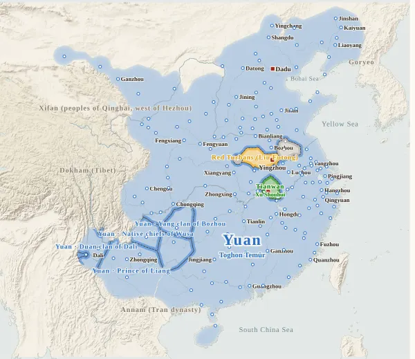
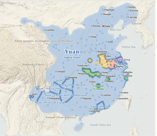
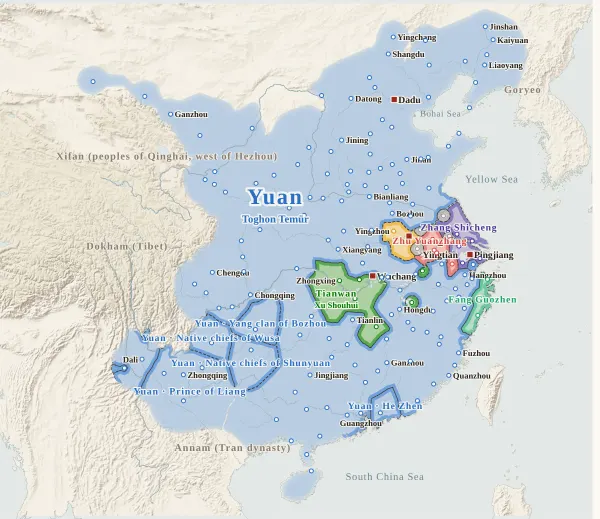
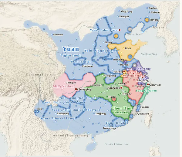
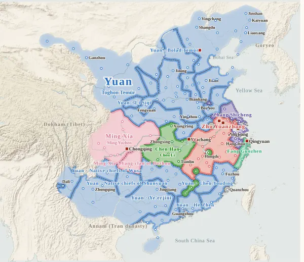
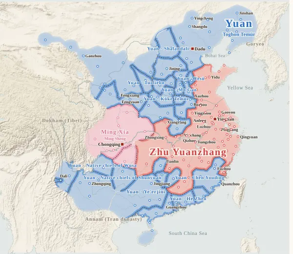
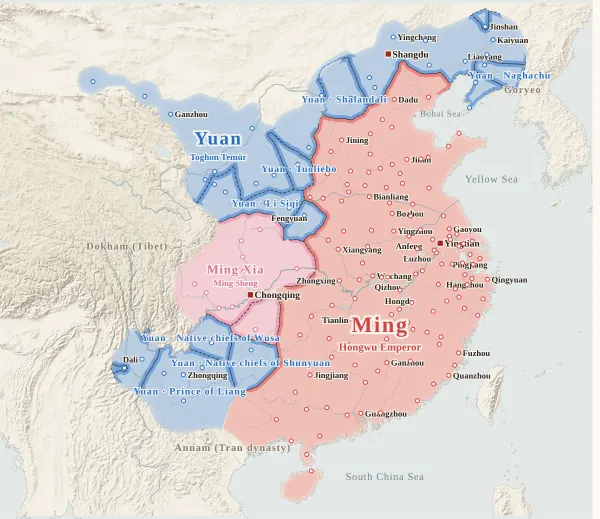
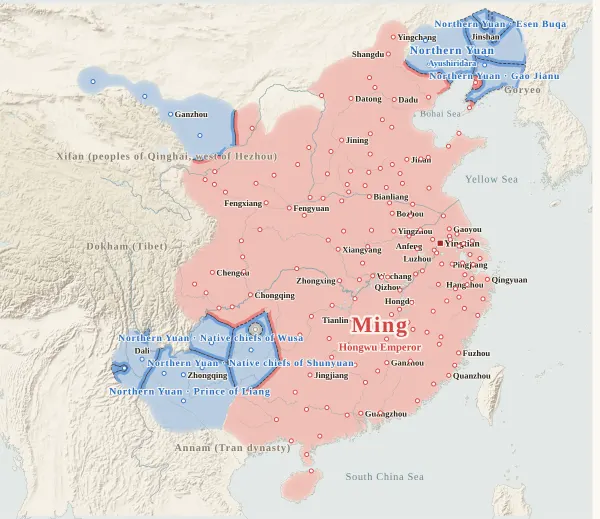
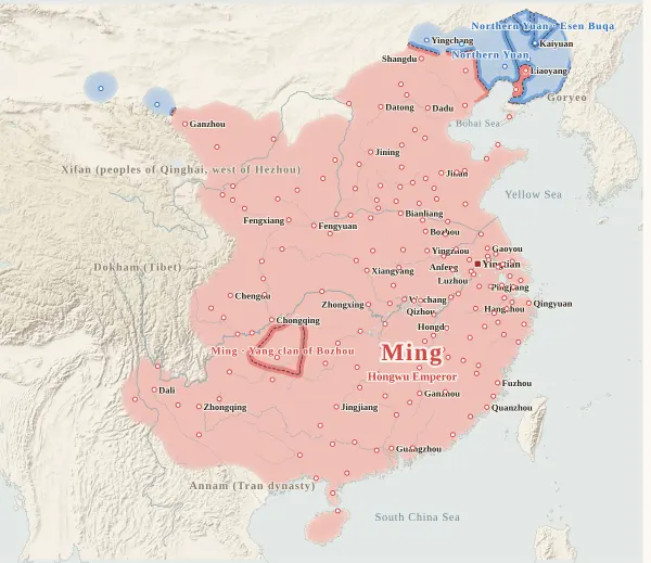
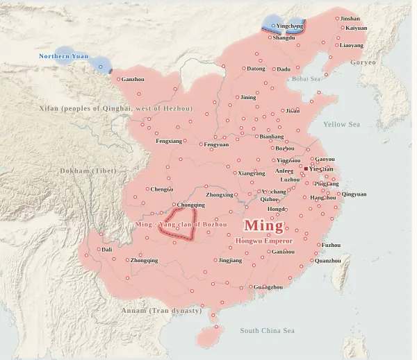
This map runs from 1351 (the eleventh year of Zhizheng under the Yuan), when the Red Turbans of Liu Futong, Xu Shouhui and others rose in arms, to 1387 (the twentieth year of Hongwu under the Ming), when Naghachu, the Northern Yuan commander left in Liaodong, surrendered to the Ming. For every year it records who held each major city at the end of the year, taken from the histories, and draws each power's territory from that. Move the year to watch the borders shift; click a city to see who held it over time, with the source passages.
Besides the Yuan (the Northern Yuan from 1370) and the Ming (Zhu Yuanzhang until 1367), the map shows every warlord who held cities. Liu Futong's Red Turbans and Han Lin'er's Song, Xu Shouhui's Tianwan, Chen Youliang's Han, Ming Yuzhen's Xia, Zhang Shicheng and Fang Guozhen have colours of their own. Small powers such as Zhima Li, Guo Zixing, Zuo Junbi and Xiong Tianrui are grey, with their names on the map. Goryeo, Annam and others appear only as names at the edge of the map.
Commanders who held regions while remaining under the Yuan (Chaghan Temür, Köke Temür, Bolad Temür, Li Siqi, Chen Youding, He Zhen, the Prince of Liang, Naghachu and others) keep the Yuan colour, separated by border lines and labelled with their names. Zhang Shicheng and Fang Guozhen submitted to the Yuan for a time and accepted its offices, but they kept ruling their territory with their own troops, so each keeps its own colour. Until 1367 Zhu Yuanzhang was nominally a subject of Han Lin'er's Song, but he is drawn in a colour separate from the Song.
The darker bands mark the borders between powers. Where the colour fades out, no city's control can be said to have reached (steppe, desert, plateau, the uplands of non-Han peoples), and no border is drawn. The red square marks the capital that year. Under the year slider, the upper band shows the Yuan turning into the Northern Yuan, and the lower band Zhu Yuanzhang turning into the Ming; click one to jump to its first year.
Under each state's name is the emperor reigning at the end of that year. No name appears for those who did not claim the title, or in years when they had not: Zhang Shicheng, Fang Guozhen, Zhu Yuanzhang (until 1367) and Ming Yuzhen (1360–1361). Han Lin'er was driven from Anfeng in 1363 and took refuge with Zhu Yuanzhang, holding no more cities, so from 1363 the Song is no longer on the map. This site covers the Northern Yuan emperors only up to Ayushiridara (died 1378), so from the end of 1378 no name appears under the Northern Yuan.
Years are Chinese calendar years. Events of the twelfth month count in that year, though by the Western calendar they may fall in January or February of the next: Han Lin'er died in the twelfth month of the twenty-sixth year of Zhizheng, which was January 1367.
How this map was made
For 173 major cities, we took from the histories who held each one at the end of each year, and attached the source passage to every change of hands. The Zizhi Tongjian does not cover this period, so the main source is the Xu Zizhi Tongjian (up to the fall of Dadu in 1368), checked against the History of Yuan, the History of Ming and the New History of Yuan: 828 passages in all, each machine-checked to appear word for word in the relevant line of the text, and for the Xu Zizhi Tongjian, the History of Yuan and the History of Ming, the year of each passage was also checked against the year on the map. Where the books disagree on a year, the Xu Zizhi Tongjian is followed up to 1368. After the research, separate reviewers for each of 11 regions checked 436 entries against the texts again, and errors and omissions were corrected at 13 cities in all. Sieges and occupations given up within the year do not change a city's holder.
Where Yuan officials of a circuit or prefecture went over to a warlord together with their city, the city is counted as that warlord's. The native chieftains of Yunnan and Guizhou (the Duan clan of Dali, Wusa, Shunyuan, and the Yang clan of Bozhou) are drawn in the colour of the power they followed, with their own names, and marked “nominal”.
The borders are inferred by machine from who held the cities. The land is divided into 4 km squares, and each square is given to the power whose city can be reached from it with the least effort, allowing for steep mountains and the difficulty of crossing great rivers. Land far from every city (steppe, desert, plateau, the uplands of non-Han peoples) is left uncoloured, with the colour fading out.
Where the cities of one power lie apart and its colour breaks off, they are joined by a band along a route that does not cross another power's land (up to about 400 km on level ground). Gaps surrounded on all sides by the powers' land and the sea, and gaps in the mountains south of the Qinling that reach deep into a power's land, are filled with the colour of the nearest power. A city surrounded by another power's land (an exclave) is drawn as a circle about 36 km in radius.
Borders at the time were zones rather than lines, and the lines on this map show only roughly where those zones lay.
Limits
- The year Ming Yuzhen took Jiading, Chengdu and other cities of Sichuan is given as 1361 by the Xu Zizhi Tongjian and the History of Yuan; this map follows the New History of Yuan and the biography of Ming Yuzhen in the History of Ming and puts it in 1359 (reading 1361 as the year the news reached the court). For other cities, where the books disagree on a year, the Xu Zizhi Tongjian is followed.
- Some things cannot be settled from the texts: the year Raozhou, lost to the Han in 1363, returned to Zhu Yuanzhang; the year the Han retook Qizhou, which had gone over to Zhu Yuanzhang in 1361; who held Chizhou in 1356; and the year He Zhen entered Guangzhou.
- Beyond the Great Wall after the Ming sent armies north (Yingchang, Xinghe, Ganzhou), the year the Ming took a city is known, but there are almost no records of whether it held on or when the Northern Yuan returned. Ganzhou is marked “nominal”: a Yuan commander surrendered it in 1372, but the Ming army soon withdrew.
- Five changes are inferred without a supporting passage (Qishui 1357, Mianyang 1353, Xiangyang 1364, Shangzhou 1369, Suide 1369). Click a city to see them marked “inferred”.
- City dots are placed at the present-day city or county, not at the exact ancient site. The interior of Yunnan, Guizhou and Lingnan has few cities, and the histories make it hard to say how far the warlords' control reached there.
- Coastlines and most rivers are modern. The Yellow River is drawn on its course after Jia Lu's river works of 1351 (the southern course from Kaifeng past Xuzhou into the Huai).
- The Yuan, the Northern Yuan and the Ming use the site's dynasty colours; the others have colours of their own on this map. Liu Futong's Red Turbans and the Song, Tianwan and the Han, and Ming Yuzhen and the Xia share colours because each pair was one line.
Sources and licences
- Texts of the histories: the Daizhige (殆知閣) digital texts (quotations kept in simplified characters). Xu Zizhi Tongjian, History of Yuan, History of Ming, New History of Yuan
- Coastlines, rivers and lakes: Natural Earth (public domain)
- Relief shading: NOAA ETOPO1 (public domain)
Japanese version
The Japanese version of this map also shows what happened each year, notes on every uncertain point, and the source passages (in Classical Chinese) for each change of hands: 元末の勢力図.