Map of the Ming–Qing Transition
1616–1683 · About this map
Loading the map…
1616
This year
Tap a city on the map, or a city name below, to see who held it year by year.
Key years
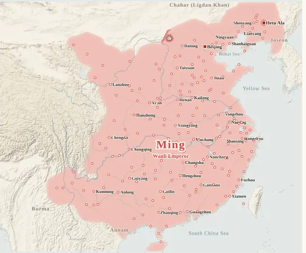 1616Nurhaci founds Later Jin
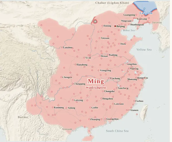 1619Battle of Sarhu
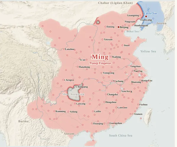 1621Later Jin takes Liaoyang and Shenyang
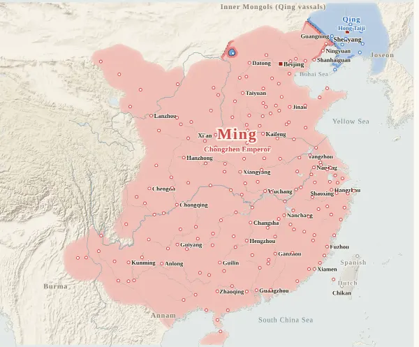 1636The state is renamed Qing
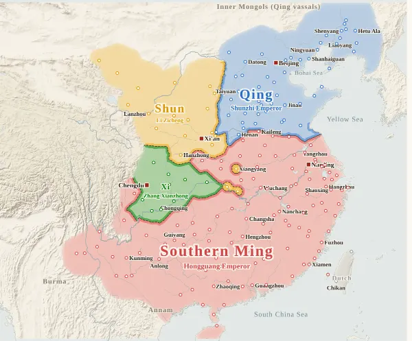 1644Li Zicheng takes Beijing; the Qing enter the Pass
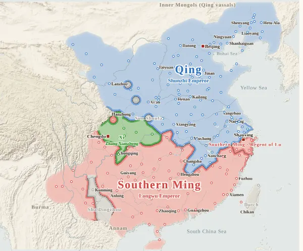 1645Nanjing falls
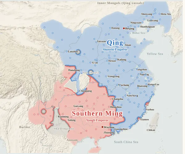 1646Longwu dies; Yongli takes the throne
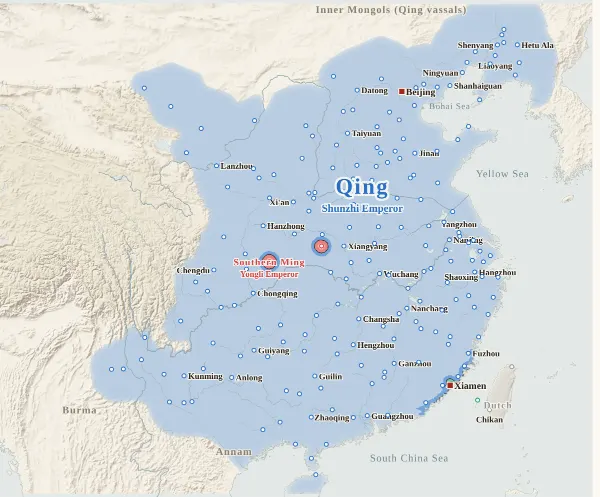 1659Yongli flees to Burma
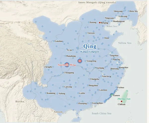 1661Zheng Chenggong takes Taiwan
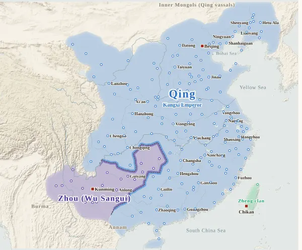 1673Revolt of the Three Feudatories
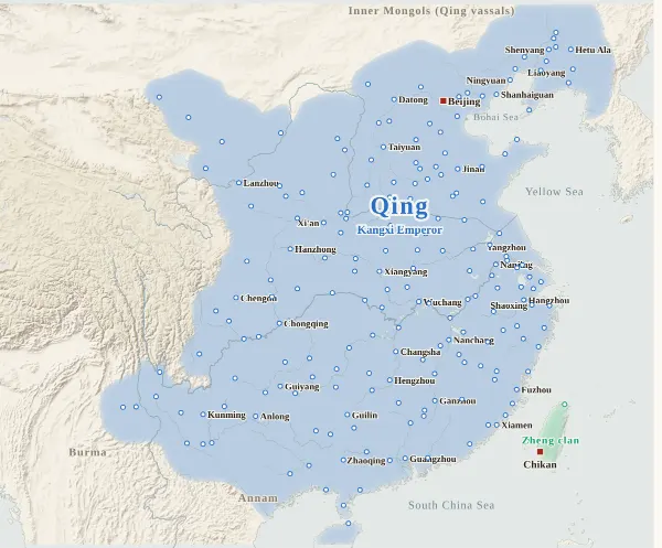 1681The Three Feudatories revolt ends
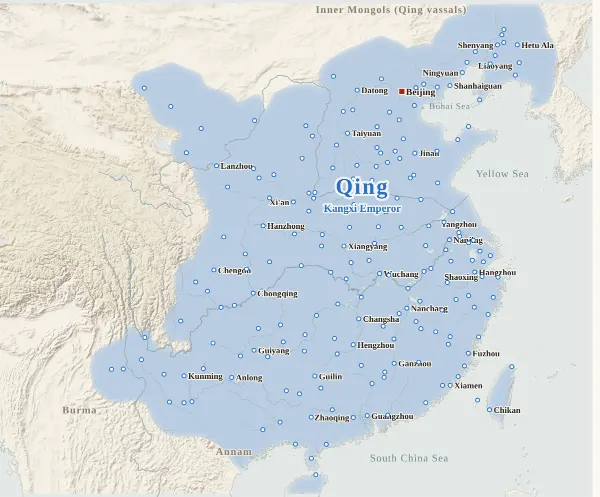 1683The Zheng surrender to the Qing
Emperors of the Ming and Qing periods
36 rulers claimed the title of emperor in these periods. Each dynasty's page lists its emperors with their reigns and causes of death.
About this map
This map covers the years from 1616 (the 44th year of Wanli of the Ming), when Nurhaci founded Later Jin, to 1683 (the 22nd year of Kangxi of the Qing), when the Zheng clan on Taiwan surrendered to the Qing. For every year it records who held each major city at the end of the year, taken from the histories, and draws each power's territory from that. Move the year to watch the borders shift; click a city to see who held it, year by year, with the source passages.
Besides the Ming (the Southern Ming from 1644) and Later Jin (the Qing from 1636), the map shows every power that held cities. Li Zicheng's Shun, Zhang Xianzhong's Xi, the Zheng clan (Zheng Chenggong and his descendants) and Wu Sangui's Zhou have colours of their own. Powers such as Sun Kewang, Sha Dingzhou, Geng Jingzhong and Sun Yanling, and the Dutch and Spanish on Taiwan, are grey, with their names on the map.
The Southern Ming courts of the Hongguang emperor (Nanjing), the Longwu emperor (Fuzhou) and the Yongli emperor (Zhaoqing and elsewhere) were one line of succession on the move, so they are drawn as one state, with the name of the court added in brackets in each city's history. Only the Regent of Lu in Zhejiang and Zhoushan, who never claimed the title of emperor, is set apart by a border and his name, in the same colour. The Shaowu emperor in Guangzhou was set up in the eleventh month of 1646, and Guangzhou fell to the Qing in the twelfth month, so he does not appear on a map drawn at the end of each year.
The darker bands mark the borders between powers. Where the colour fades out, no city's control can be said to have reached (steppe, desert, plateau, the uplands of non-Han peoples), and no border is drawn. The red square marks the capital where an emperor or king was at the end of the year (it is left out in years when the court kept moving and it is not known which city it was in at the year's end, as with the Yongli emperor of the Southern Ming or Wu Sangui). The bands under the year slider show the Ming and Southern Ming on the top row and Later Jin and the Qing on the bottom row; click one to jump to its first year.
Under each state's name is the emperor reigning at the end of that year. Nurhaci (Taizu of Later Jin), the Regent of Lu and the Zheng clan are not counted as emperors on this site, so no names appear for them. The “Dashun emperor” under Zhang Xianzhong's Xi is named after his era name, Dashun, and has nothing to do with Li Zicheng's state of Shun. Wu Sangui called himself King of Zhou from his rising in 1673 until he proclaimed himself emperor at Hengzhou in 1678, so no name appears under Zhou in those years. The Yongli emperor was handed over from Burma to Wu Sangui in the twelfth month of 1661, so from the end of 1661 no name appears under the Southern Ming.
Years are Chinese calendar years. Events of the twelfth month count in that year, though by the modern calendar they may fall in January or February of the next (the twelfth month of the second year of Longwu, when the Shaowu emperor died, was January 1647 by the modern calendar).
How this map was made
For 197 major cities, we took from the histories who held each one at the end of each year, and attached the source passage to every change of hands. The Zizhi Tongjian does not cover this period, so the main sources are the History of Ming, the Draft History of Qing and the Southern Ming annals Xiaotian Jinian, checked against the Xiaotian Jizhuan and the Mingji Nanlüe: 1,342 passages in all, each machine-checked to appear word for word in the text. For passages from the Xiaotian Jinian, the year of the entry was matched against the year on the map; for the History of Ming and the Draft History of Qing, the era year in the text was matched against the year on the map. After the research, separate checkers re-read 726 entries against the texts, region by region in eight regions, and corrected 16 for errors or omissions. Sieges, occupations given up within the year, and cities that the roving armies of Li Zicheng and Zhang Xianzhong or the Qing raids across the Great Wall merely passed through do not change a city's holder.
Where Ming officials surrendered a city to Li Zicheng, Zhang Xianzhong or the Qing, the city is counted as belonging to the side it went over to. Cities that went on to follow the Southern Ming after the Ming fell at Beijing in the third month of 1644, in the interval before the Hongguang emperor was enthroned at Nanjing, are drawn as passing directly from the Ming to the Southern Ming.
The borders are inferred by machine from who held the cities. The land is divided into 4 km squares, and each square is given to the power whose city can be reached from it with the least effort, allowing for steep mountains and the difficulty of crossing great rivers. Land far from every city (steppe, desert, plateau, the uplands of non-Han peoples) is left uncoloured and fades out.
Where the cities of one power lie apart and its colour breaks off, they are joined by a band along a route that does not cross another power's land (up to about 400 km on level ground). Gaps surrounded on all sides by the powers' land and the sea, and gaps in the mountains south of the Qinling that reach deep into a power's land, are filled with the colour of the nearest power, except around cities that the histories say belonged to no one. A city surrounded by another power's land (an exclave) is drawn as a circle about 36 km in radius.
Borders at the time were zones rather than lines, and the lines on this map show only roughly where those zones lay.
Limits
- At the end of 1646, Guizhou, Yunnan and Funing are shown as still following the Longwu court. The Longwu emperor died in the eighth month of that year, but the Xiaotian Jizhuan says the Yongli emperor's edicts did not reach Yunnan. Guizhou and Funing have not been confirmed.
- Guangning is counted as belonging to no one from 1622, when Later Jin took it and withdrew, until 1634, and as a Later Jin city from 1635. The evidence for 1635 is weak.
- Sichuan was laid waste from 1646 and few records name who held its cities, so Chengdu in 1646–1651 and Dazhou and Shunqing in 1646–1647 are counted as belonging to no one.
- During the Revolt of the Three Feudatories, no records were found of the years in which Guangxi (Wuzhou in 1675–1676, and Taipingfu) left the Qing or was retaken by it, or of Gaozhou in 1678, so these remain undecided.
- Five changes are placed without a passage (Penghu in 1646, Jilong in 1626 and 1642, Baoqing in 1650, Qingyuan in 1674). The Spanish at Jilong in northern Taiwan (1626–1642) do not appear in the histories used. Clicking such a city shows “inferred”.
- City dots are placed at the present-day city or county, not at the exact ancient site. The interior of Guizhou, Yunnan and Guangxi and the land beyond the Great Wall have few cities, and the histories make it hard to say how far each power's control reached there.
- Coastlines and most rivers are modern. The Yellow River is drawn on its Ming–Qing course (the southern course from north of Kaifeng through Xuzhou, joining the Huai at Qingkou and reaching the sea at Yuntiguan).
- The Ming and Southern Ming share one colour, as do Later Jin and the Qing. The Ming and Qing use the site's dynasty colours; the others have colours of their own on this map.
Sources and licences
- Texts of the histories: the Daizhige (殆知閣) digital texts (quotations kept in simplified characters): the History of Ming, the Draft History of Qing, the Xiaotian Jinian, the Xiaotian Jizhuan and the Mingji Nanlüe
- Coastlines, rivers and lakes: Natural Earth (public domain)
- Relief shading: NOAA ETOPO1 (public domain)
Japanese version
The Japanese version of this map also shows what happened each year, notes on every uncertain point, and the source passages (in Classical Chinese) for each change of hands: 明清交替の勢力図.