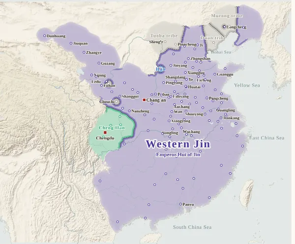
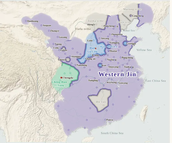
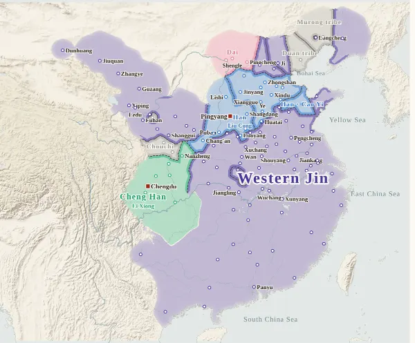
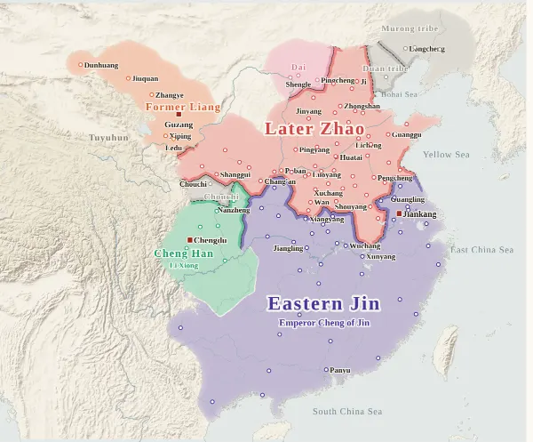
Map of the Sixteen Kingdoms
300–439 · About this map
Loading the map…
300
This year
Tap a city on the map, or a city name below, to see who held it year by year.
Emperors of the Sixteen Kingdoms and Jin periods
60 rulers claimed the title of emperor in these periods. Each dynasty's page lists its emperors with their reigns and causes of death.
About this map
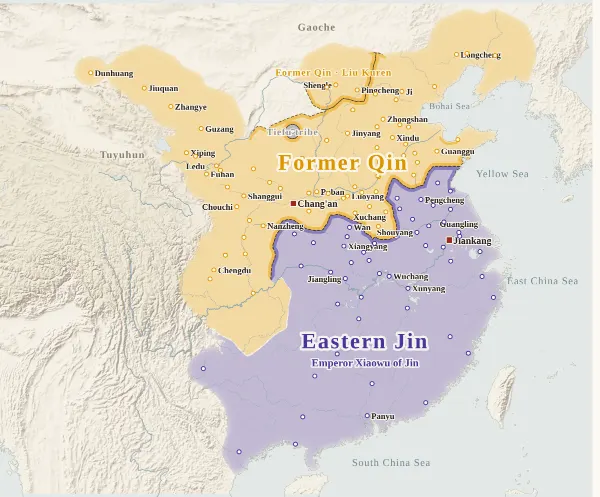
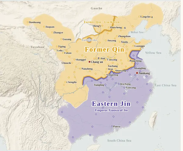
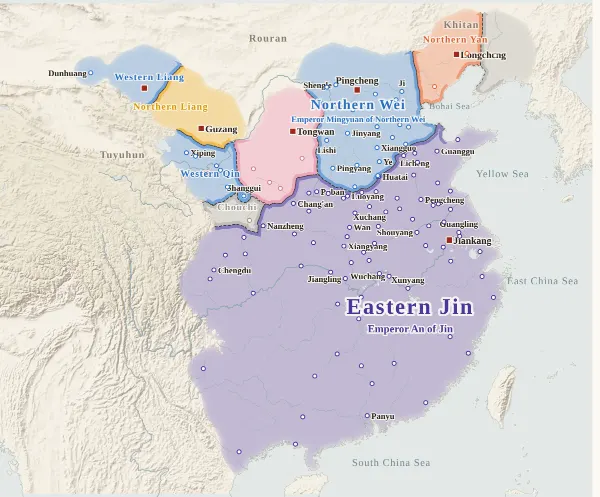
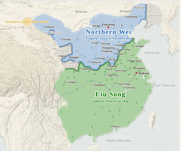
This map runs from 300, when Western Jin still held China together, to 439, when Northern Wei unified the north. For every year it records which state held each city at the end of the year, taken from the histories, and draws each state's territory from that. Move the year to watch the borders shift; click a city to see who held it, year by year, with the source passage. This map overlaps the Northern and Southern Dynasties map in 420–439; for those 20 years both maps use the same cities, the same holders and the same drawing rules, so the same year gives the same map.
The darker bands mark the borders between states. Where the colour fades out, no city's control can be said to have reached (steppe, mountains), and no border is drawn. The red square marks each state's capital that year. The bands under the year slider show, on the upper row, the main states of the north (when two stood side by side, the eastern one above and the western one below), and on the lower row Jin and Liu Song; click one to jump to its first year. The states of the Hexi Corridor, western Liaoning and Shu are not shown in the bands.
Under each state's name is the emperor reigning at the end of that year. Years in which the ruler did not call himself emperor but “king” or “heavenly king” (Shi Hu of Later Zhao, Fu Jian of Former Qin, Yao Xing of Later Qin from 399, Northern Wei until 397, and others), and states that never claimed the title (most of Former Liang, Western Qin, Later Liang, Southern Liang, Northern Liang, Western Liang, Northern Yan and Dai), show no name. Nor do years in which an emperor was killed or gave up the throne during the year and there was no emperor at its end (Huan Chu in 404, for example). “The end of the year” is the last day of the Chinese calendar year: Huan Xuan took the throne in the twelfth month of the second year of Yuanxing, which fell in January 404 by the Western calendar but counts here as the end of 403.
How this map was made
For 126 major cities (not shown in years before a city or garrison was set up), we took from the histories which state's inspector, governor or commanding officer was there at the end of each year, and attached the source passage to every change of hands. The main source is the Zizhi Tongjian, checked against the Book of Jin (including its “Records” of the Sixteen Kingdoms), the Book of Wei and the Book of Song: 1,228 passages in all, each machine-checked to appear word for word in the text, and, for the Zizhi Tongjian, to fall under the heading of that year. Sieges and occupations given up within the year do not change a city's holder. Years in which a city cannot be said to belong to anyone (Luoyang in ruins, for example) are left uncoloured.
The borders are inferred by machine from who held the cities. The land is divided into 4 km squares, and each square is given to the state whose city can be reached from it with the least effort, allowing for steep mountains and the difficulty of crossing great rivers. Land far from every city (steppe, plateau, the uplands of non-Han peoples) is left uncoloured and fades out.
Where the cities of one state lie apart and its colour breaks off, they are joined by a band along a route that does not cross another state's land (up to about 400 km on level ground). Gaps surrounded on all sides by the states' land and the sea, and gaps in the mountains south of the Qinling that reach deep into a state's land (today's Guizhou, western Hunan and so on), are filled with the colour of the nearest state. A city surrounded by another state's land (an exclave) is drawn as a circle about 36 km in radius, because dividing the land halfway between cities would make an exclave look larger than it was. Commanderies and counties also lay within these areas, but as they have no city dot on the map, actual control there was thinner than around the cities.
Borders at the time were zones rather than lines, and the lines on this map show only roughly where those zones lay.
Limits
- Few records of this period name who held a city. For 82 changes of hands there is no passage on the city itself, and the change is inferred from nearby cities or from the state as a whole (marked “inferred” when you click a city). Inferences are most frequent in Henan, Hebei and Guanzhong during the collapse of Later Zhao (349–352) and of Former Qin (384–394).
- When Former Yan fell (370) and all its provinces and commanderies surrendered to Former Qin, when Huan Xuan took the throne and the Jin heartland became Huan Chu (403), and when Huan Chu fell and the Jin court returned to Jiankang (404), cities were moved to the new holder all together, as with a change of state, even without a passage on each city. Huan Chu was the state in which Huan Xuan seized the Jin throne and took over Jin's land as it stood (from the twelfth month of 403 to 404), so it is drawn in the same purple as Jin and told apart by its name and border lines. Mao Qu in Shu (Yi Province) rose against Huan Xuan only at the start of 404, so at the end of 403 Shu too is shown as Huan Chu.
- City dots are placed at the present-day city or county, not at the ancient site. Identifications follow Hu Sanxing's commentary. Guanggu (the capital of Southern Yan) lay in the western outskirts of today's Qingzhou, and its dot is placed at Qingzhou.
- The steppe lands of the Tuoba state of Dai and of Northern Wei, the western end of the Hexi Corridor (Gaochang, west of Dunhuang, lies off the map), and frontier regions such as Ning Province (today's Yunnan) and Jiao Province (northern Vietnam) are places where the histories do not make clear how far control actually reached.
- In 430 Western Qin abandoned its base around Fuhan and moved to Nan'an (which has no city dot on the map), so it disappears from the map a year before its fall in 431. Northern Liang surrendered to Northern Wei at Guzang in 439, but its remnants held Dunhuang, so on the map for the end of that year Dunhuang alone remains Northern Liang.
- Coastlines and most rivers are modern. Only the lower Yellow River (its course from the Later Han on), the lower Huai (before Hongze Lake formed), the Si and the Luo are redrawn as rough lines through points they passed at the time.
- States that have no dynasty colour on the site (Ran Wei, Former Liang, Western Qin, Later Liang, Southern Liang, Northern Liang, Western Liang, Northern Yan and Dai) have colours of their own on this map. Southern Yan shares Northern Wei's blue on the site, and the two were neighbours, so on this map Southern Yan is pink. With too few colours, some states far apart at the same time share one: tell them apart by name. Western and Eastern Jin, and Han and Han Zhao, share a colour because only the name changed. Huan Chu, as above, shares Jin's colour.
Sources and licences
- Texts of the histories: the Daizhige (殆知閣) digital texts (quotations kept in simplified characters)
- Coastlines, rivers and lakes: Natural Earth (public domain)
- Relief shading: NOAA ETOPO1 (public domain)
- Other map data used for cross-checking: the Seshat Global History Databank's “Cliopatria” (CC BY 4.0). Its time steps are coarse, and it is not incorporated into this map.
Japanese version
The Japanese version of this map also shows what happened each year, notes on every uncertain point, and the source passages (in Classical Chinese) for each change of hands: 五胡十六国の勢力図.