Map of the Five Dynasties and Ten Kingdoms
907–979 · About this map
Loading the map…
907
This year
Tap a city on the map, or a city name below, to see who held it year by year.
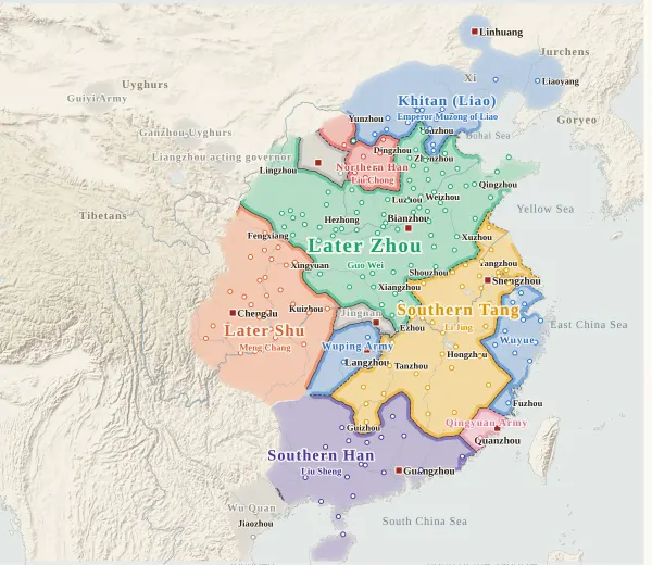
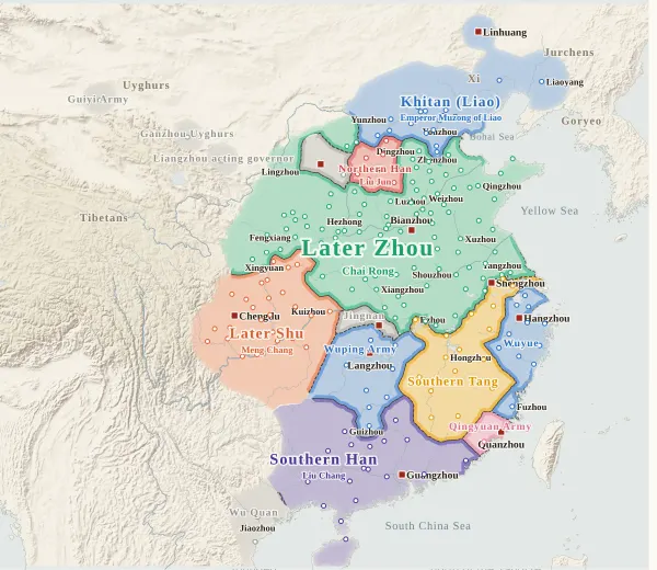
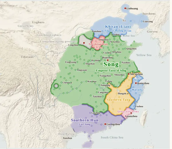
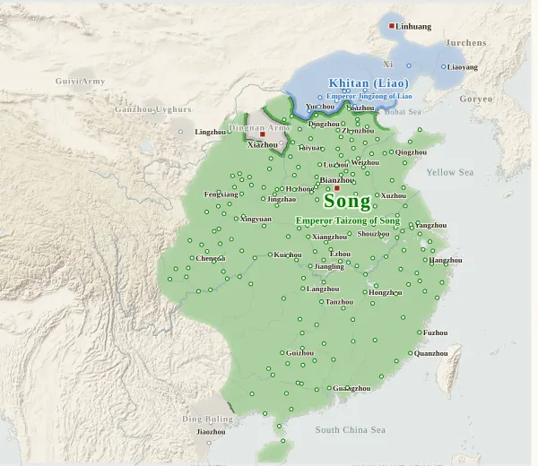
Emperors of the Five Dynasties and Ten Kingdoms and Song periods
52 rulers claimed the title of emperor in these periods. Each dynasty's page lists its emperors with their reigns and causes of death.
About this map
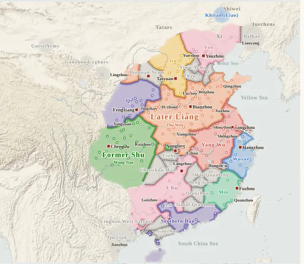
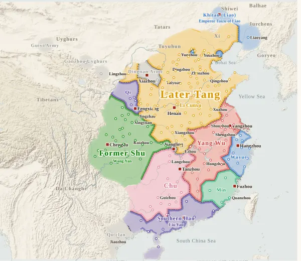
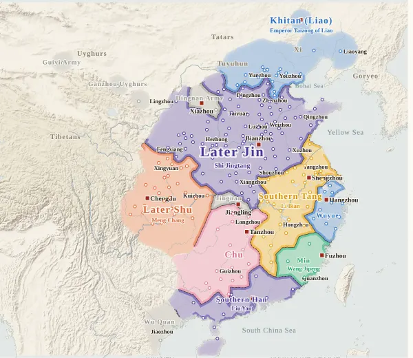
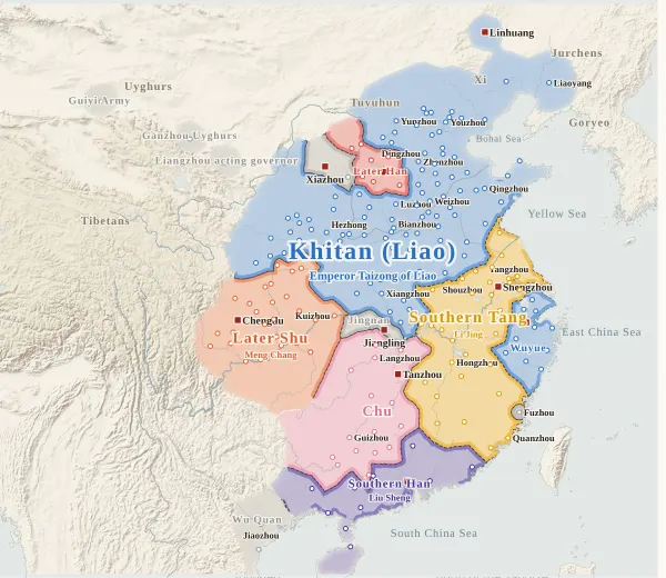
This map covers the years from 907, when Zhu Quanzhong seized the throne from Tang and founded Later Liang, to 979, when Song brought Northern Han to surrender and united China. For every year it records who held each prefecture at the end of the year, taken from the histories, and draws each power's territory from that. Move the year to watch the borders shift; click a prefecture to see who held it, year by year, with the source passages.
The map shows the Five Dynasties that succeeded one another in north China (Later Liang, Later Tang, Later Jin, Later Han and Later Zhou) and Song; the Ten Kingdoms (Wu (Yang Wu), Southern Tang, Wuyue, Min, Chu, Southern Han, Former Shu, Later Shu, Jingnan and Northern Han); the Khitan (Liao) in the north; and the powers that were in fact independent: the Jin of Li Keyong and Li Cunxu (later Later Tang), the Qi of Li Maozhen, the Yan of Liu Rengong and Liu Shouguang, the Dingnan Army of Xiazhou, the Yin founded by Wang Yanzheng of Min, the Qingyuan Army of Quanzhou and Zhangzhou, the Wuping Army after the fall of Chu, and the Qu, Wu and Ding families of Annam (today's northern Vietnam). Military governors who rebelled and held out in their cities (Li Shouzhen, Zhao Siwan and others) are not counted as powers; they are grey, with only their names shown.
The darker bands mark the borders between powers. Where the colour fades out, no prefecture's control can be said to have reached (nomad lands, mountains), and no border is drawn. The red square marks each power's capital that year. The bands under the year slider show, from the top, the northern dynasties (the Five Dynasties and Song), Wu and Southern Tang, and Former Shu and Later Shu; click one to jump to its first year.
Under each state's name is the emperor reigning at the end of that year. States that never claimed the title of emperor (Jin, Qi, Wuyue, Chu, Jingnan and others), and years before a state claimed it, show no name. Southern Tang ceded its land north of the Yangtze to Later Zhou in 958 and gave up the imperial title, so no name appears after that. “The end of the year” is the last day of the Chinese calendar year: Emperor Chu of Later Jin surrendered to the Khitan in the twelfth month of the third year of Kaiyun, which fell in January 947 by the Western calendar but counts here as the end of 946.
How this map was made
For 216 major prefectures, we took from the histories who held each one at the end of each year (whose military governor, prefect or commanding general was there) and attached the source passage to every change of hands. The main sources are the Zizhi Tongjian and, from 960, the Xu Zizhi Tongjian Changbian, checked against the Old and New Histories of the Five Dynasties, the History of Song, the History of Liao and the Spring and Autumn Annals of the Ten Kingdoms: 1,075 passages in all, each machine-checked to appear word for word in the text, and those from the Zizhi Tongjian and the Changbian to fall under the heading of the right year. After the survey, separate checkers went through each region against the texts again and corrected errors. Sieges and occupations given up within the year do not change a prefecture's holder.
In a year when one of the Five Dynasties replaced another, the prefectures held by the old dynasty at the end of the previous year are all passed to the new one (a change of hands is recorded even where there is no passage for that city in that year).
The borders are inferred by machine from who held the prefectures. The land is divided into 4 km squares, and each square is given to the power whose prefecture can be reached from it with the least effort, allowing for steep mountains and the difficulty of crossing great rivers. Land far from every prefecture (steppe, plateau, the uplands of non-Han peoples) is left uncoloured, fading out.
Where the prefectures of one power lie apart, they are joined by a band along a route that does not cross another power's land (up to about 400 km on level ground). Gaps surrounded on all sides by the powers' land and the sea, and gaps in the mountains south of the Qinling that reach deep into a power's land, are filled with the colour of the nearest power. A prefecture surrounded by another power's land (an exclave) is drawn as a circle about 36 km in radius.
Borders at the time were zones rather than lines, and the lines on this map show only roughly where those zones lay.
Limits
- Emperor Chu of Later Jin surrendered to the Khitan at the end of 946 (the twelfth month of the third year of Kaiyun), so on the 946 map all of Later Jin's prefectures are in the Khitan colour, except Hedong, which did not submit to the Khitan (Liu Zhiyuan, who claimed the throne in the second month of 947 and founded Later Han), shown in the Later Han colour. In fact Khitan troops never reached many prefectures, and Qin, Jie, Cheng and Feng prefectures went over to Later Shu in 947. From 947 the map follows the records prefecture by prefecture.
- Few records describe the handover of each of the Sixteen Prefectures to the Khitan. Apart from Yun, Ying, Shuo and Xin, the years are inferred from the promise to cede them (936) and the record of the Khitan making Youzhou their Southern Capital (937): You, Ji, Shun, Tan, Zhuo, Ying and Shuo in 936; Xin, Gui, Wu and Yun in 937; and Ying, Mo and Yu in 938.
- Some distant places that acknowledged a power only in name, though whether it actually governed them is doubtful, are coloured for that power (marked “nominal” in a prefecture's history): Lingzhou (the Han family of Shuofang), Cangzhou and Dezhou under Later Liang, and Wang Chuzhi and Wang Du of Dingzhou, who followed Jin and Later Tang. Liangzhou, Ganzhou and Shazhou in the Hexi Corridor sent envoys to the dynasties of the Central Plain but were held by local powers (the acting governor of Liangzhou, the Ganzhou Uyghurs, the Guiyi Army), so they are grey.
- Where the histories do not give the year a prefecture was retaken, the change is placed in the earliest year it can be confirmed as that power's. Northern Han retaking Lanzhou from Song is placed in 976 (the year Northern Han's patrol commissioner of Lanzhou was captured), and retaking Liaozhou from Later Zhou in 961 (the year a Northern Han prefect of Liaozhou appears). Yang Chongxun of Linzhou submitted to Later Zhou once in 952, but in 957 he surrendered to Later Zhou as Northern Han's prefect, so Linzhou is Northern Han until 957. After Song took Liaozhou in 964 a Northern Han prefect of Liaozhou still appears in the histories; since it cannot be decided who held the city, it stays with Song.
- Where the histories disagree on a year, the Zizhi Tongjian is followed. Chu's Lian, Zhao, Liu and Xiang prefectures passed to Southern Han in 951 according to the Zizhi Tongjian, but in 950 according to the geographical tables of the Spring and Autumn Annals of the Ten Kingdoms. For Southern Tang's prefectures north of the Yangtze taken by Later Zhou (Guang, Chu, He and others), the records divide between 957 and 958 for some of them.
- Annam (today's northern Vietnam) follows the succession of the Qu family, Yang Tingyi, Jiao Gongxian, Wu Quan and Ding Buling as recorded in the Chinese histories; what they do not record, such as the struggles after Wu Quan's death, is not shown. Dali (after Nanzhao) and Balhae (destroyed by the Khitan in 926) have no prefecture dots.
- Prefecture dots are placed at the present-day city or county, not at the exact ancient site; the identifications follow mainly Hu Sanxing's commentary. Only 216 major prefectures have dots; Weizhou, Zhongzhou, Tongzhou, Yunzhou and others do not.
- Coastlines and most rivers are modern. Only the lower Yellow River (the course it followed from the Eastern Han to 1048), the lower Huai (before Hongze Lake formed), the Si and the Luo are redrawn as rough lines through points they passed at the time.
- Later Liang, Song and the Khitan use the site's dynasty colours; the other Five Dynasties and the Ten Kingdoms have colours of their own on this map (on the rest of the site all the Five Dynasties are orange). With too few colours, states that did not exist at the same time or lay far apart sometimes share one (gold for Later Tang and Southern Tang; orange for Later Liang and Later Shu; blue for Wuyue, the Wuping Army and the Khitan; pink for Chu, the Qingyuan Army and Yan; purple for Later Jin, Southern Han and Qi; red for Yang Wu, Later Han and Northern Han; green for Former Shu and Song; teal for Min and Later Zhou): tell them apart by name. Jin and Later Tang, Later Han and Northern Han, and Min and Yin share colours because they were one family. Jingnan, the Dingnan Army and the small powers are grey.
Sources and licences
- Texts of the histories: the Daizhige (殆知閣) digital texts (quotations kept in simplified characters): the Zizhi Tongjian, the Zizhi Tongjian with Hu Sanxing's commentary, the Xu Zizhi Tongjian Changbian, the Old History of the Five Dynasties, the New History of the Five Dynasties, the History of Song, the History of Liao and the Spring and Autumn Annals of the Ten Kingdoms
- Coastlines, rivers and lakes: Natural Earth (public domain)
- Relief shading: NOAA ETOPO1 (public domain)
Japanese version
The Japanese version of this map also shows what happened each year, notes on every uncertain point, and the source passages (in Classical Chinese) for each change of hands: 五代十国の勢力図.