Map of the Fall of Sui and the Rise of Tang
613–628 · About this map
Loading the map…
613
This year
Tap a city on the map, or a city name below, to see who held it year by year.
Emperors of the Late Sui and Sui periods
17 rulers claimed the title of emperor in these periods. Each dynasty's page lists its emperors with their reigns and causes of death.
About this map
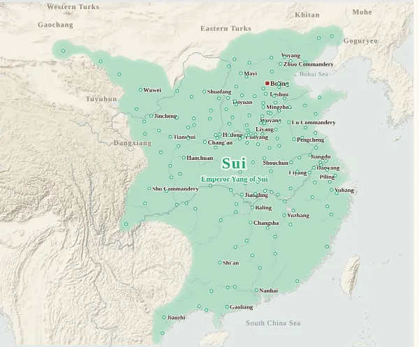
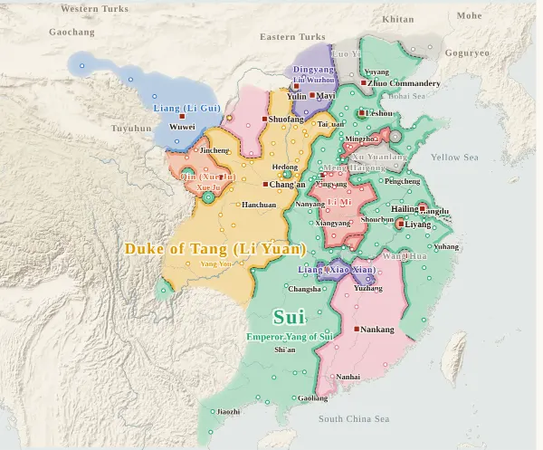
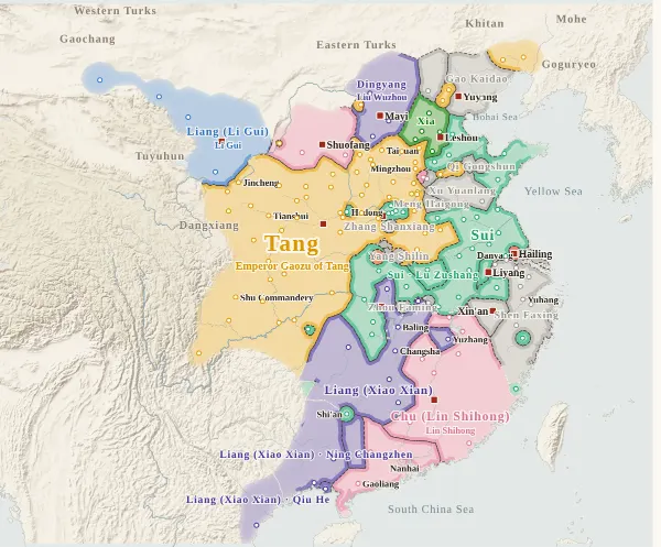
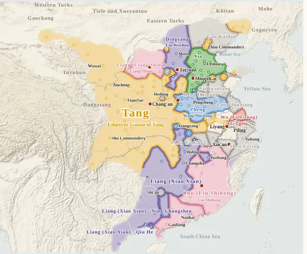
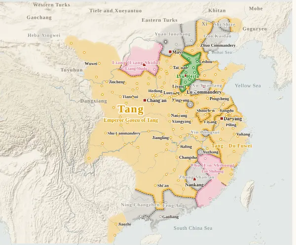
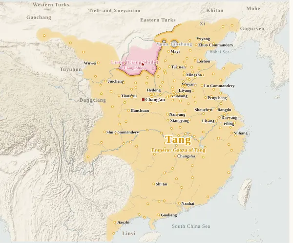
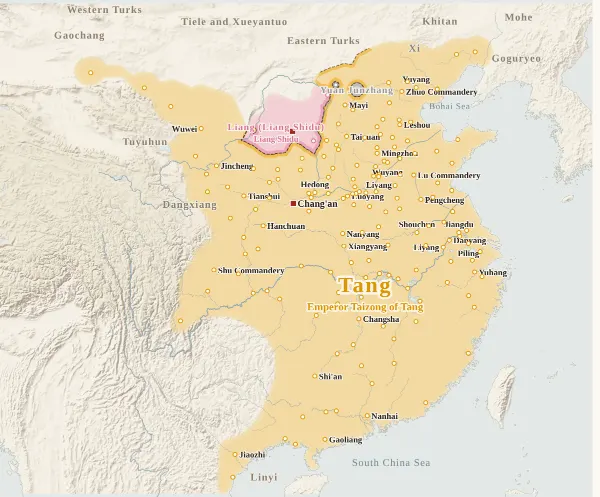
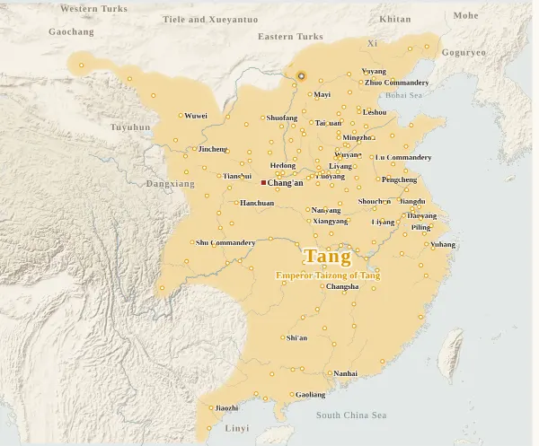
This map runs from 613 (the ninth year of Daye under Sui), when Yang Xuangan raised troops, to 628 (the second year of Zhenguan), when Liang Shidu, the last of the rebel powers, fell and Tang unified the realm. For every year it records who held each major city at the end of the year, taken from the histories, and draws each power's territory from that. Move the year to watch the borders shift; click a city to see who held it, year by year, with the source passage.
Besides Sui and Tang (in 617, Li Yuan, Duke of Tang, who had raised troops), the map shows every rebel power that held cities. Li Mi, Wang Shichong's Zheng, Dou Jiande's Xia, Liu Heita, Liu Wuzhou's Dingyang, Liang Shidu, Xue Ju's Qin, Li Gui's Liang, Yuwen Huaji's Xu, Xiao Xian's Liang, Lin Shihong's Chu, Zhu Can's Chu, Du Fuwei, Li Zitong's Wu and Fu Gongshi's Song have colours of their own. Smaller powers such as Luo Yi, Gao Kaidao, Xu Yuanlang, Shen Faxing, Wang Hua and Feng Ang are grey, with their names on the map. The Turks, the Tuyuhun, Goguryeo and others appear only as names at the edge of the map.
The darker bands mark the borders between powers. Where the colour fades out, no city's control can be said to have reached (nomad lands, mountains), and no border is drawn. The red square marks each power's capital that year. The band under the year slider shows the passage from Sui to Tang; in 617–618 it is split in two, because Sui and Li Yuan, Duke of Tang (from 618, Tang), stood side by side. Click it to jump to its first year.
Under each state's name is the emperor reigning at the end of that year. For 617, Emperor Yang at Jiangdu appears under Sui, and Emperor Gong (Yang You), whom Li Yuan set up at Chang'an, appears under the Duke of Tang. Emperor Gong (Yang Tong, the Huangtai ruler), raised at the Eastern Capital in 618, is treated on this site as a rival emperor to Yang You, so no name appears under Sui at the end of 618. Rebel leaders who never claimed the title of emperor, such as Dou Jiande (King of Xia), Li Mi (Duke of Wei), Du Fuwei and Liu Heita, have no name either, and neither do the years before a claim (such as Xiao Xian in 617).
Years follow the way the Zizhi Tongjian assigns them. Events of the twelfth month belong to that year, though they can fall in January or February of the next year by the Western calendar (Lin Shihong proclaimed himself emperor in the twelfth month of the twelfth year of Daye, which was January 617).
How this map was made
For 168 major cities, we took from the histories who held each one at the end of each year and attached the source passage to every change of hands. The main source is the Zizhi Tongjian, checked against the Book of Sui and the Old and New Books of Tang: 784 passages in all, each machine-checked to appear word for word in the text, and those from the Zizhi Tongjian to sit under the heading of the right year. After the research, separate checkers went back to the text for 407 entries across 13 regions and corrected 17 errors and 5 omissions. Sieges and temporary occupations given up within the year do not change a city's holder.
Where a Sui commandery administrator surrendered his whole commandery to a rebel power, its cities are counted as that power's. Places that submitted to Tang and took Tang offices are in Tang's colour. Du Fuwei (619–621), Gao Kaidao and Guo Zihe, who submitted but went on governing with their own troops, are in Tang's colour with their own names attached, marked “nominal”. Du Fuwei's nominal allegiance is taken to end when he went to court at Chang'an in 622.
The borders are inferred by machine from who held the cities. The land is divided into 4 km squares, and each square is given to the power whose city can be reached from it with the least effort, allowing for steep mountains and the difficulty of crossing great rivers. Land far from every city (steppe, desert, plateau, the uplands of non-Han peoples) is left uncoloured, with the colour fading out.
Where the cities of one power lie apart, they are joined by a band along a route that does not cross another power's land (up to about 400 km on level ground). Gaps surrounded on all sides by the powers' land and the sea, and gaps in the mountains south of the Qinling that reach deep into a power's land, are filled with the colour of the nearest power, except around cities that cannot be said to belong to anyone, which are left blank even where a neighbouring power could reach them. A city surrounded by another power's land (an exclave) is drawn as a circle about 36 km in radius.
Borders at the time were zones rather than lines, and the lines on this map show only roughly where those zones lay.
Limits
- After Wang Shichong took the throne from the Sui court at the Eastern Capital (the Huangtai ruler) in 619, seven cities in the Jiang-Huai region and the south (Gaomi, Xuyi, Zhongli, Lujiang, Xuancheng, Yongjia and Jian'an) are left as belonging to no one (blank), because no passage names them as becoming Tang's or a rebel power's.
- The year Ba and Shu came over to Tang follows the Zizhi Tongjian's entry for the twelfth month of 617 (Zhan Jun and Li Xiaogong were sent to win them over), but the actual submission may be read as early 618.
- Lin Shihong's Jiangxi (Jiujiang, Poyang and Yichun) is placed under Tang from 621 on the strength of the geography treatise of the Old Book of Tang; he may have held it until he surrendered in 622. Likewise, cities whose only evidence is a note in the geography treatises of the two Books of Tang that a prefecture was set up in a given year of Wude (Honghua, Lanzhou, Xiangcheng, Runan, Zhongli, Lujiang and Jian'an) may be a year off.
- Who held Cangzhou, Liyang, Ji Commandery and Weixian at the end of 621 and 622, when Liu Heita rose again, is inferred from undated passages. Also undecided: whether Fuhan (Hezhou) belonged to Xue Ju or Li Gui in 617–618, whether Donghai in 619 belonged to Zang Junxiang or to Jiang Hongdu, who had surrendered to Tang, whether Guangzhou in 620 belonged to Feng Ang or Deng Wenjin, and the year Yingzhou (Liucheng) returned to Tang.
- City dots are placed at the present-day city or county, not at the ancient site. Deep in Lingnan and the south there are few cities, and how far the rebel powers' control reached is hard to settle from the histories.
- Coastlines and most rivers are modern. The Yellow River follows its course after the Later Han flood works.
- Sui and Tang use the site's dynasty colours; the others have colours of their own on this map. With too few colours, powers that did not overlap in time or lay far apart sometimes share one (blue for Zheng and Li Gui; pink for Liang Shidu, Yuwen Huaji and Lin Shihong; orange for Xue Ju, Zhu Can, Du Fuwei and Fu Gongshi; purple for Liu Wuzhou and Xiao Xian; red for Li Mi and Li Zitong): tell them apart by name. Li Yuan as Duke of Tang and Tang, Dou Jiande and Liu Heita, and Du Fuwei and Fu Gongshi share colours because they were one line.
Sources and licences
- Texts of the histories: the Daizhige (殆知閣) digital texts (quotations kept in simplified characters): the Zizhi Tongjian (with Hu Sanxing's commentary), the Book of Sui, the Old Book of Tang and the New Book of Tang
- Coastlines, rivers and lakes: Natural Earth (public domain)
- Relief shading: NOAA ETOPO1 (public domain)
Japanese version
The Japanese version of this map also shows what happened each year, notes on every uncertain point, and the source passages (in Classical Chinese) for each change of hands: 隋末唐初の勢力図.